19 September 2016

Takao - Shiroyama Saturday Spin

On Saturday I took a short (~95km) trip with Jerome and Didier in not-too-hot but stiflingly humid weather.   We started late, amid heavy traffic, and needed to return early. At Takao, an overheating Jerome took a dip in the Asagawa.


Many passersby chuckled.  A few applauded.
Orange cosmos hide the Parlee Altum-R and Gokiso wheels.
Fun to ride a zippy road bike after lots of randonneuring the past month! 
Then we took Machida Kaido and did the climb to Shiroyama Dam, finally a route without traffic on the climb and descent.  Then back to town via the "tank road" and Onekan. As Jerome warned from a recent trip, two-thirds of the length of the "tank road" was mobbed with zombies staring at smartphones playing "pokemon go".
I pinch flatted near the bottom of the last descent on Onekan going over a big gap at the beginning of the last bridge ... Too late I realized that I had high rim wheels, short/mid-length valves on my spare tubes and no valve extender.  I patched my flat tube ... and made it another 4~5 kms.  There followed a number of attempts at a fix, none successful, and in the end I rode a few kms on the flat tube with JJ and DD to Seo Cycles north of Komae, got a valve extender, and was able to ride home.

I cannot wait for cooler, dry weather. But Sunday and Monday has been rainy, and the next week looks like more of the same.

18 September 2016

Cycling in Seattle in September

Lake Washington -- from Warren Magnuson Park boat launch ramp
I recently spent a week in Seattle, at and around the University of Washington. I must say that I was impressed with the support that Seattle offers for cycling, in many ways similar to that seen in Portland, its neighbor to the South. My past experience with Seattle, featuring Interstate 5 traffic jams, a big city downtown, and a couple of seemingly endless local trips out to the suburbs during rush hour, had led me to think that Seattle might not be a good place to be a cyclist. I stand corrected.
Typical I-5 traffic approaching Seattle from the South 730AM one morning.
The first revelation was the bike share program -- lime-ish green bikes sponsored by Alaska Airlines, in contrast to Portland's orange Nike-sponsored bikes and New York's Citigroup bikes. These bikes have been around much longer than Portland's, and the racks I saw -- one just a block from my hotel -- had many open slots with bikes out for use (or repair).
Bike share station in the University District
The second revelation was on the SIR brevet.  I could not discern much leaving town starting from 6AM Saturday and heading out to the South/Southeast along the shore of Lake Washington. Of course, at that hour, there was almost no traffic.
On a trail near Renton southeast of Seattle. Gravel surface here.
But coming back into town along the paved Burke-Gilman trail was really great. This route brought us more than 25 kms from the edge of town all the way past the University, all on a dedicated trail. Most of the way it was relatively wide, smooth and fast. Somehow in a very hilly city, it managed to avoid any steep grades -- understandable where it is a former railroad bed.  Of course, the hard-core SIR members on the "gravel grinder" included a number of folks who ride everywhere, in city as well as out.

Then on Tuesday at the university, I noticed some nice support for cyclists - parking with a roof, bike storage lockers, pumps and repair tools available, convenient parking. This is summarized at the UW bikeshare website, which notes that UW is a "Bicycle Friendly University", the only one in Washington, America's most bicycle friendly state! And on a ferry trip to Bainbridge Island for dinner at a friend's places, I could see many spandex-clad cyclists, taking the ferry on an intermodal ferry/bicycle commute.
At least there is a roof over your bike when it rains.
No need to bring wrenches on a daily commute
$140 a year according to the UW bikeshare website.  Lots of other support.


The beauty of Seattle's skyline from the ferry -- photos do not do it justice. Magical on a calm, warm evening.


Next, mid-week, I took a ride on the Bantam Oregon randonneur bike into town to visit a high school friend who lives between Seattle Center and downtown.  Most of the way I was in a bike lane or otherwise a well-travelled commuter route.  Very nice.

The next day I took a quick exercise ride back out to the North and East of the University District.  I thought I would find Burke-Gilman, but somehow missed it and ended up at Warren Magnuson Park. Eventually I found the trail and took in on a very fast return trip.

Appropriate sculpture for Boeing's town - airplane stabilizers as sculpture at Magnuson Park.

Rain always close, even when you can see blue sky.
If Portland is Beervana, Seattle is coffee paradise. The city is home to Starbucks, of course, but also Tully's and Seattle's Best, among myriad others.
All-in-all, a very bikeable city, even if fenders and good rain gear needed most of the year!
Mt. Rainier from my hotel -- finally shows itself fully near end of the week!

09 September 2016

The Spectacular SIR Summer "Gravel Grinder" 600k!

This was the most that Mt. Rainer showed itself during the entire 2 day circumnavigation. ... big tease of a mountain!
The Seattle International Randonneurs' "Summer 600" ride around Mt. Rainier was held this past weekend.  When I first mentioned the idea of joining to Vincent last month, he warned me that this one looked pretty tough.
Sure, there were 6400 meters of climbing, heading up over Paradise on the south side of Mt. Rainier, then back down, then up over Cayuse Pass and Chinook Pass on the east side of Mt. Rainier, then the much lower Ellensburg and Snoqualmie Passes on the return trip.  But 6400 meters of climbing over a 600k brevet (actually, 615k for this route) ... is really not so extraordinary when compared to our rides in Japan.  Jerome and I did a "regular" 600k event back in 2012 or 2013 with Kanagawa Audax that had over 7500 meters of elevation gain.  And my first 600k brevet ever in Japan back in 2010 had at least as much climbing as this one.
Route of the SIR Summer 600, from RidewithGPS
But Vinny was not referring to the climbing.  No, he was thinking of the road conditions.  The route we would travel includes over 150 kms of gravel/dirt surfaced roads and trails, including some very nasty "washboard" sections that will rattle your bones and shake loose your teeth fillings.  I had never ridden any kind of distance on dirt/gravel.  Maybe 10kms on one of the roads near Yabitsu Pass was the most I could recall.  And that was slow going, with cyclocross tires.
The pre-ride report by Mark Vande Kamp pretty much confirmed that this was an incredible, and incredibly difficult, route.  In fact, I really don't need to give a full description of the event since the SIR pre-ride report says it all. As Mark summed it up:
  • "we saw volcanoes, glaciers, rivers, rain forests, dry pine forests, shrub-steppe, and sub-alpine environments. We saw an orange moon rise over the ridge. We rode in the silent pre-dawn darkness and saw the pink light on the hills. We had a big 600k experience.
Wow, that sounded attractive to me.
On the other hand, riding 600km on smooth roads is a lot easier than riding it on gravel. This I can now state with confidence.
As Mark also noted:
  • "we felt heat-stress, cramps, sleepiness, muscle fatigue, hunger, thirst, hand pain, butt pain, neck pain, nausea, and general discomfort."
Given this report, it was no surprise that only around 15 riders showed up at the start, as Vinny described it, some of the "hard core" of the SIR membership.
In my case, the description of the pre-ride pretty much matched my experience.  I had no real heat-stress or cramps, and no nausea.  But the stiff, constant headwinds from Ellensburg to Hyak were an added challenge late in the event.
On an early unpaved but very smooth stretch Saturday morning between Renton and Black Diamond heading out of Seattle.
Of course, there is an enormous amount of energy absorbed when your wheel slips or gravel slides as you try to push forward. And there is more energy loss as you bump up and down on the surface. And the general rolling resistance is higher.  The two longest unpaved sections were maybe 20kms of awful road between Naches and Ellensburg, and then a very long stretch (60kms?) on the "Iron Horse Trail" over Snoqualmie Pass -- a barely perceptible, gradual climb followed by a slightly steeper (1 or 2%!) descent, then a section on the Snoqualmie Valley trail.  If these had all been paved roads, I am pretty sure I could have completed the ride 3-4 hours faster, or more. The section between Naches and Ellensburg would have taken probably 90 minutes less. And the 100kms on the Iron Horse Trail would have been a breeze.
I was grateful that, even if I had not actually ridden such long gravel stretches before, I have READ about them in Jan Heine's Bicycle Quarterly. And Hahn Rossman, who works with Jan and had been at the 2014 Japan fleche closing party in Kamakura, was on the staff at this event.  Audax really is a small world, and you can see the same people at various events around the globe if you just travel a bit!
Typical stretch of road on the climb to Ellensburg Pass -- average, with a few stretches much worse than this.
Typical stretch (except add washboard) on the descent from Ellensburg Pass.
The SIR organizers/staff for the ride (Ryan, Hahn, Steve ... any others who I missed?) did a great job -- Ryan Hamilton's house served as the start/goal, with a nice place to sit in the side yard/patio (and enjoy a beer) after we wrapped up.  And the overnight control at Naches offered some hot food (and a beer) upon arrival, safe bike storage, coffee and another bite before heading out, and an actual hotel room bed (or part of a bed, for one or two who ended up sharing) to get a few hours of sleep.
The organizers also kindly warned us that the time deadlines on the return leg would be difficult, and that we really should leave Naches around 4AM to make sure to get to the Ellensburg control by the 8:28AM cut off.  That's right, four-and-a-half hours for a segment that is only 56 kms and includes only 600~650 meters of elevation gain, and finishes with a nice downhill? It sounds crazy, and I took it with a grain of salt, not leaving the Naches control until maybe 4:20.  I arrived at Ellensburg with 8 minutes to spare.  One flat tire and I would not have made it.
Heading out of Seattle, Nigel and Cheryl on the tandem down from BC
Vinny early on, riding his 650Bx42 tire titanium brevet machine.  I did not see him between maybe km 140 and the finish.  He left Naches at 3AM and was many hours ahead at the finish, as expected.
Riding gravel requires different equipment selection.  I was very glad to have the Oregon Randonneur bike with 700x30 Grand Bois tires still in good condition and inflated to 70~75psi (I let out a bit of air at Naches so was probably at 60~65psi on the return).  I made it through the entire event with no, that's right zero, flat tires or tubes.  The only rider who completed the event on a road bike with 700x23mm tires, Mitch, had 3 flats and finished after me, despite being a much faster rider.  I might have been even happier if I had had a bike equipped with 650B x 42mm tires.  Vincent and others on 650Bx42 could ride the gravel with more confidence, more speed and less slippage. 

The Oregon randonneur with a 3-bottle set up and no fenders again.
I made good time as far as the 128km Eatonville control, remembering some of the route from Cascade 1200.  I struggled between Eatonville and Longmire, fatigue setting in and lack of sleep in the prior few days of transit/early wake-up catching up with me. 
A U.S. convenience store - typically attached to a gasoline station.
This one, in Black Diamond, did have hot breakfast biscuit sandwiches (non-McD egg mcmuffins).
Typical of the roads between Black Diamond and Eatonville

Looking back toward Ohop Lake between Electron/Clay City and Eatonville
The last 15kms to Longmire followed a national forest road.  This was dirt -- or more accurately mud -- at least at the beginning.  There was a local fellow standing beside his parked car at the entrance as I rode by.  He asked "are you heading to Longmire"?  "Yep".  "Well, you must be going the right way because I've seen 4 others come by. Good luck."  The "good luck" was delivered with a kind of skeptical "you must be crazy to head up this road" sense to it.  

Pre-modern gasoline stand at Longmire, in Rainier National Park, where we rejoined the main road to Paradise.
Anyway, my fatigue did not lift at Longmire, where I ended up taking only a short rest and filling my water bottles and chatting a bit with John and Shiggy, two of the other riders.  800+ meters of climbing left from Longmire to Paradise.  In my condition I figured the only way would be to divide it up into shorter segments, with short rests.  I did so, 200 meters elevation gain at a time, and made it to Paradise after 5PM, but still more than 2 hours ahead of the deadline.
On the climb to Paradise

Paradise!  But still a bit more climbing left to the visitor center/control
The section of the ride between Paradise and Cayuse Pass was spectacular.  I have never been (or at least do not remember) traveling this SE side of Mt. Rainier.  The old growth forest was beautiful, the roads were not crowded.  I want to go back. 
Looking South across a meadow at Paradise

Old growth forest on the SE side of Rainier, just past
"Grove of the Patriarchs. I almost expected to see an Ewok, or a Sasquatch, or at least a black bear.
The road toward Cayuse Pass, Washington Rte 123
Looking back at Rainier -- barely visible
Descending to the East on the SE side of Rainier
And I felt recovered enough to climb to Cayuse and Chinook without any major problems.  I was far back in the pack at this point, but at Paradise, Ryan had told me there were still 4 riders behind me.  And even though Shiggy had gone ahead, I could see John's tail-light at various points on the climb to Cayuse, and caught up with him before Chinook.  We started the descent together, and eventually I went ahead, feeling full of energy and enjoying the tailwind.  We were together again at the control in Cliffdell, where we entered the bar and enjoyed some country music while getting some (non-alcoholic) refreshment.  John needed food, so I pressed on and was at Naches at 12:50AM, fed, showered and in bed by 1:30AM for a 4AM wakeup.
Pink morning clouds before 6AM on Sunday 


We saw a lot of beautiful sky, clouds, and stars on this brevet
The second day was all about time management.  8 minutes to spare at Ellensburg (km 397.3), then a miserable headwind from Ellensburg to Cle Elum (made much easier by Hugh, as we traded pulls until I ran out of gas at some point and he did most of the pulling).  Then the long gravel slog over the Iron Horse Trail (see pre-ride report for details on conditions -- I would only add that the deep gravel around various gates along the trail made it all much harder.  I got to the North Bend control (km 533.8) with 10 minutes to spare, following Jeff the last few kms.
Yakima River between Ellensburg and Cle Elum. Miserable headwinds here.

A few miles outside of Ellensburg

I only snapped one photo at the west exit to the tunnel at Snoqualmie Pass.  Not a moment to waste.
The tunnel was over 4 kms long, and unlit, with an uneven floor and some dripping water from the ceiling.
I passed a few cyclists and at least 30 walkers inside.
From North Bend, it looked like there was plenty of time to get to the Woodinville control, and I joined (and then passed) 3 riders - John, Hugh and Jeff - on the trail after North Bend, so it would be easy, right?  Then I noticed that it was almost 30 kilometers from the Woodinville control to the finish, but Woodinville closed at 916PM, while the finish deadline was 10PM.  Only 44 minutes for 27.6 kms? No way!  Yes way.  The course was 616.2 kms in length, but the time deadline was 40 hours -- standard for any 600km brevet.  So the last 16.2 kms did not get any time allocation.  Fortunately, I was able to get to Woodinville around 825PM, after dark now, but with plenty of time for the last 27.6kms. 
My Garmin died, and my mind was confused.  As I continued beyond the Woodinville control I looked at my cue sheet for navigation and pulled out my phone and tried to load the ridewithgps route. I would need it with no cyclecomputer or measure of distances. It looked as if I was supposed to join yet another trail in Woodinville.  I was fumbling around in the dark, grabbing some food from my bag and trying to figure it out when John, Jeff and Hugh came by, across the street.  
I hopped on the train and rode with them all the way to the finish.  This last 25 kms was reminiscent of the end of the Cascade 1200, when we rode in a nice group at a relaxed pace from the last control, near the "lanterne rouge" position.  
3+ kms later that we joined the trail I had been looking for -- the Burke Gilman Trail.  This trail is PAVED, and WIDE, and includes underpasses for busy intersections, and it took us all the way to the Univ. of Washington Campus and beyond, over 20 kilometers of easy, relatively flat riding, much of it along the NW shore of Lake Washington.  I was thinking "if I ever live in Seattle, this is an area where I could live and easily get into town - at least to the university - by bicycle."  At one point, Hugh reminded John, our pace-maker, that we could not be TOO relaxed, since we had slowed to around 15kph, and had only one hour to go the remaining almost 15 kms.  We sped up.  Jeff zoomed off ahead.
And so, as we rolled up to Ryan's house at 9:46PM Sunday, with 14 minutes to spare, then sat down and enjoyed the post-ride beer and some nice food, Randonesia had already begun to set in.
Then it was back to my hotel and off to sleep.  A deep, deep, satisfying 9 hour sleep, followed by a short day of activity then another deep, deep long sleep of 10+ hours on Monday night.  And more long sleep on Tuesday night.
Thank you, SIR, for a great 600k experience. 

07 September 2016

Farewell Garmin, You have Served Me Well


It happened just before dark on Sunday, as I entered the Seattle area on the last leg of the Seattle International Randonneurs "gravel grinder Summer 600". My Garmin Edge 800, still showing plenty of battery after the umpteenth recharge and one mid-ride reset, crashed.
It has happened before, but this time it shows no life. Did I just imagine a slight whiff of fried electronics? I think, "you are finally gone".

Thank you, Edge 800, for your years of service in extreme conditions. Despite your buggy software, lack of good instructions, and that little chip in your front plastic touchscreen (a kind of "beauty mark"--actually a scar from when I dropped you onto hard pavement long ago) you have served me well and given your all.

Rest in peace.

UPDATE:  Sadly, the Garmin is still dead four days later. I have tried to charge its batteries and it gets quite warm -- almost hot -- from the charger, something I have never noticed before.  The electronics must be deeply troubled, beyond repair.

Time to experiment with my iPhone as a navigation device?

01 September 2016

Biketown ... or Beervana


Portland, Oregon, now has a cycle rental/sharing program like New York, London, Paris and many other cities (and some wards of Tokyo).  It is sponsored by Nike, headquartered in the Portland suburbs, so the bikes and stations are the same orange as Nike shoe boxes.  Of course, official Nike stores are called "Niketown" so the bike program seems to go by "Biketown."

I did not see many people using the orange bikes, since most Portlanders who want to ride a bike ... have one of their own and use it daily.  But I was glad to see a news report this evening (Aug 31) that the program exceeded its first month target, with more than 59,000 trips recorded.

The "Biketown" name is a bit lame, whether for a bike sharing program or a city. After a visit to one of Portland's 65 breweries for some craft beer yesterday, I think "Beervana"is the winner.

30 August 2016

Randonneuring in Oregon, on the Oregon Randonneur Bike


On Saturday I joined the Oregon Randonneurs' ("ORR") 400km Lebanon/Dee Wright Observatory Brevet, in near perfect weather.

This was the first time I have ridden a brevet in Oregon (Portland, Oregon being my hometown and where my parents still live). It also was my first brevet on the custom, purpose-built "Oregon Randonneur Bike" that Bob Kamzelski of Bantam Bicycle Works built for me last year and I initiated at Cycle Oregon 2015.

Vincent, who came to Hokkaido for the 1200km in July, made the trip from Seattle for this one, and I joined him and another SIR member, Audunn, for dinner on Friday evening near the start.

Of course, brevets are unsupported long-distance events, usually very spartan. Some Audax clubs go out of the way to provide some refreshments, or a manned "control point", a snack or a cup of soup at the finish.  Of course, the longest and largest events provide more -- meals, showers and sleeping facilities along the way. I was told the Oregon rides are at the spartan end of the spectrum.  The pricing (free entry) certainly matched.

Indeed, this ride had only 8 participants on 7 bicycles (one tandem), including 3 from the Washington-based Seattle International Randonneurs club, one from the east-of-the-mountains Desert River Randonneurs and myself visiting from Japam.  (There was another Oregon ride the same weekend -- a 600km -- and both were styled as "makeup rides" for anyone who had missed another earlier in the year).  The ORR representative who staffed the ride emailed us in advance to warn that he would be joining the ride, so riders would need to show up  at 5AM sharp or be left without a card (but also, no worries, if we lost or rode without a card -- it would all be figured out in the end).  It was a welcome relaxed approach to the brevet rules, in contrast with Japanese "a rule is a rule" bureaucracy.

The ride had two challenges for me: first, nearly 3800 meters of climbing, and second, extremely limited opportunities to get food and water en route.  No 24 hour 7-11 or Lawson convenience stores. No vending machines by roadside in the middle of nowhere like in Japan.
Elevation profile for the initial 260 (out of 400) kilometers - 3 long climbs, 2 of them with over 1000 meters elevation gain.
We started at 5AM sharp from Lebanon, Oregon, a town on the eastern edge of the Willamette Valley SE of Albany (which is South of Salem and North of Eugene).  It was still pitch dark, unlike a 5AM start in Japan.  After a warm up stretch on dark country roads, we eventually started a long climb up a paved National Forest road that peaked out at km 96 or so at around 1250 meters elevation.  I was a bit worried that with US Route 20 to the south closed down temporarily, there might be extra traffic on this road.  I needed have worried. There was almost no traffic.
Dawn at the reservoir East of Sweet Home, Oregon
Ward and Audunn climb ahead


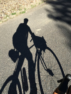
Who is that big shadow?
View from the top toward the East
Along the climb, which paralleled a reservoir then creek, there were many families camped -- trucks and SUVs, tents, tables and cooking gear all visible, with the occasional boat or dog.  I rode with Ward and Audunn of SIR until about the 70 km mark, as the road turned up and I fell back.  As usual, Vinny started slow and then just got faster and faster.
Inside the restaurant at Marion Forks. The river runs just beyond the patio in back.
The first control was at the restaurant at Marion Forks.  It was only when I got there (11AM) that I recognized the name or place -- I had driven by it many times on the North Santiam highway en route from Detroit Reservoir to the Sisters/Black Butte/Bend area.  I was looking forward to an early lunch, so was a bit disappointed to see Ward and Audun settling up as I entered.  They had had some pie and stocked up and were heading out.  I sat down and ordered meat loaf.  They were out, so I switched to a hamburger.  As I was waiting for my burger, Ron and Kathy pulled up on their tandem, with Bill. They got their brevet cards signed and headed back to the bike.  What, no food?  Kathy explained that the following weekend they were doing a series of 3 rides out of Baker City, each of which required that you carry all the needed food (and water). This was a training run for them and they were fully stocked on the tandem.

I was still waiting for my burger a few minutes later when Vinny pulled in around 1125AM and showed me how it is done. Instead of ordering from the menu, he asked the waitress "what do you have that is fast"?  After rejecting a few choices, she finally suggested a sandwich.  He ordered one to eat at the counter, and one to go.

I amended my order to add a turkey sandwich to go.  His sandwiches arrived before my burger!  He got the check and settled up while eating, ... so I followed suit.

In any event, we headed out at the same time and were together on the first few climbs, until he pulled away. I saw Vinny again at the last water stop before the climb to McKenzie Pass/Dee Wright Observatory (the Ollalie at Mckenzie Bridge campground), and as he descended from the pass while I still climbed.  He finished in around 21 hours, way ahead of my 23 hrs 45 mins.

The stretch after Marion Forks was for me somehow by far the hardest.  We climbed up almost as high as the pass we had come over, then had a long descent punctuated by some intermediate climbs.  But the entire stretch of 50kms was the shoulder of a busy road, and with direct sunlight and warm temperatures.  The heat was nothing like Japan, but it was still mid-day heat and sun, with speeding traffic nearby, and already nearly 2000 meters elevation gain and 150kms under the belt.  I was very happy to finally, just after 3PM, reach the entrance to the climb up to Dee Wright Observatory and realized that the winding road had little traffic and plenty of shade.
Now the main event!
I was tired and hot on the climb, despite the shade and moderate (for summer) temperatures.  At least I knew it would just get cooler as I climbed.  And I had filled 3 bottles at the Olallie campground, so would have plenty of water.  Right?  Well, I started climbing around 500 meters elevation and would be going to 1600.  By 750, I had already used 1 1/2 bottles as I slowed from exhaustion.  I pulled off at a campsite/trailhead, borrowed an empty picnic table in a "day use" area and lay down for a good, 10 minute nap.
A beautiful view lying flat on my back.
Before I left I approached a family campsite wtih 3 huge coolers.  I asked the mother if they had any spare drinking water.  She pulled out a 500ml PET bottle of water (the kind they sell at Costco?) and handed it to me.  Saved by the kindness of strangers. With this reserve and the cooling weather, I regained my confidence.

Around 1100 meters elevation, Ward and Audunn passed me heading back on the descent.  A bit further it was Ron and Kathy on the tandem, riding with Bill.  And not far apart Vinny, just as I started the long (10kms?) flattish stretch at the top toward the pass.
Finally a (mostly) flat section around 1400 meters elevation.  ~10kms and 200-250m up to the pass.
It was 6PM by the time I got to the observatory at the pass, and I sat down for some food, rationing my last bottle of water sip by sip. I was a bit worried about the headwind, VERY stiff at the top of the hill, that I would ride into on the return (fortunately, it was not a problem beyond the very first stretch).
Getting closer to the pass now. Lava flows abound.
The cue sheet required us to answer a question about the sign on the door to the restrooms at the observatory monument. There was an unmarked building that LOOKED like a restroom, but without any markings, and with a sign on the wall, not either of the doors.  The night before Audunn had said something about needing to ride a few hundred meters beyond the pass ... so I took a spin down the East side to see if there was another parking lot and more obvious control point and restroom. There was not, so I climbed back up, investigated and confirmed that, sure enough, the unmarked building was the restroom and the sign on the wall must have been the one intended.

North Sister and Middle Sister, from near McKenzie Pass

A nearly identical view.
In any event, I was still at the summit when Paul arrived, the last of the 8 riders. I was delighted to have some company and we rode relatively close together as far as the next control, 40 kms down the hill at the McKenzie Bridge General Store.
Is that South Sister just over the ridge on the descent back to McKenzie Bridge?

The store had very limited choices for food that could be eaten on the spot. Lots of junk, and some groceries and frozen food that required preparation. At least there was yogurt, an ice cream bar (my body craves milk products at this point in a long ride) and hot coffee.  On a second trip into the store I ventured into the "courtyard" out back, which I realized was where the restaurant is located.  Next trip, I will head straight for the restaurant, and ask for something fast.

But for now, there was not a moment to waste.  Paul told me to go on ahead as he wanted to keep to a deliberate, steady pace -- a tortoise to my hare -- and I rode alone the last 145 kms of the ride (except seeing Paul once more, coming into Coburg as I was leaving).  It was a fast 60 kms stretch on the highway along the McKenzie River to a turn off to Camp Creek Road.

On Camp Creek Road there was no traffic, after midnight now, and I could incredible stars, the milky way visible together with thousands of others. Perfect temperature; my body not complaining.  What a joy.  This is the kind of stretch that brought me to randonneuring back in 2010, and it is always welcome.

I made excellent time to the next control at Coburg, as my Garmin track shows.  Well, actually, my aging, always buggy Garmin Edge 800 crashed just before Coburg. It seems to have deleted my recording for this entire stretch in doing so. Anyway, I just needed to "bring it home" the last 60kms, which began with a straight, flat stretch of around 20kms.  I was thinking I could finish by 4AM or so, but then the road headed into foothills.  A few short climbs set me back, and I ended up rolling in at 4:43AM.  At the all-night gas station where we got our proof-of-finish receipts, the guy manning the gas pumps seemed to have full knowledge of what I was doing and who I was with.  He asked about the other rider, and I assured him "Paul should be along before long."

And then it was done.  No celebration.  The early riders already packed up and gone, somewhere. Vinny and Audunn back to eat and sleep again at their hotel.  I loaded up the car, got some drive-through food and coffee at the local McDonald's, napped for 30 minutes, and drove back to Portland, where I showered, bathed, and went into a deep, delightful recovery sleep.