Showing posts with label Numazu. Show all posts

25 October 2021

Saitama Audax 300km -- October 16, postponed from March 20.

After a 9-day trip to the USA for family events and visits that included two empty international long-haul and three domestic spam-in-a-full-can shorter flights, plus a 14 day quarantine at home upon my return, I was feeling very much overweight, undertrained, and in serious need of a bicycle ride.

So I was delighted that upon my return to Tokyo, I had an envelope from Saitama Audax with a brevet card, return envelope, and a note that the March 20 300km event I had planned to do to prepare for the Okayama 1200 had been rescheduled for October 17 -- the first weekend after my quarantine end date. Even better, the event would be a held as an "N2" brevet, which means that no staff are at the start or finish, and the rider can select their own start date and time within 2 weeks before or after the official event date. The weather forecast for October 17 looked very wet and nasty, so I submitted an October 16 7AM start date and time.

After 2 x 200km easy events in January, my 2 x 300km preparatory rides in March and early April had both been cancelled/postponed, I rode only the first full day of the Okayama 1200, and a partial second day, a very short 3rd day back to Onomichi, nowhere near the stamina or speed needed to complete that event. And I have been riding relatively little since, much of it with the recumbent rather than on a road bike. My physical exam in September showed me near my "peak" weight of recent years, not at all where I should be at the end of summer. And so I had a lot invested emotionally in just managing to get through a 300km event, in avoiding another DNF after PBP and Okayama. (I did not care about an official completion, so long as I did the full ride. The brevet card in the mailbox was just the perfect excuse to try now).
A worthy course, but with pretty heavy traffic on a Saturday, except for
sections ridden early morning or late evening.
Jerome came along for the exercise and to offer moral support. 
From the start next to the Irumagawa in Saitama, I felt sluggish and went slowly. The course wound through SW Saitama, then Okutama, then Sagamihara, to reach the foot of Doshi Michi and climb to Yamanakako.  
At the start - Irumagawa

Ready to ride.

An early forced stop -- there goes the 300km record attempt!

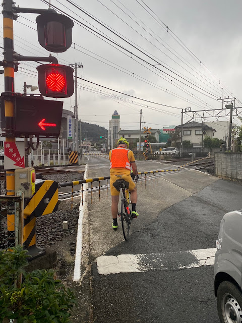
We had already climbed over 600 meters by the time we got onto Doshi Michi, if memory serves. Jerome went way ahead the entire first half of the event, waiting for me each our or so. I did not realize Jerome had stopped to wait at the 7-11 on lower Doshi, and ended up passing him. He caught me at the spring where I was refilling my bottles and went ahead to the Michi-no-eki, where we both rested a bit. He waited again at the tunnel at the top.
On Doshi Michi -- the Olympic RR course, lest we forget


At the Doshi Michi Michi-no-Eki

It had rained a bit at the start, but the road was dry and the rain stopped, until Yamanakako. There the rain restarted in earnest. On the descent from Kagozaka Pass to Subashiri was the only part of the event that was actually cold, heavy rain, our own wind from descending, and the elevation all contributing.  We stopped at an eat-in convenience store in Gotemba, refueled and warmed up a bit before continuing onto the next significant climb, around 375m elevation gain up to the entrance to Fuji Safari Park.
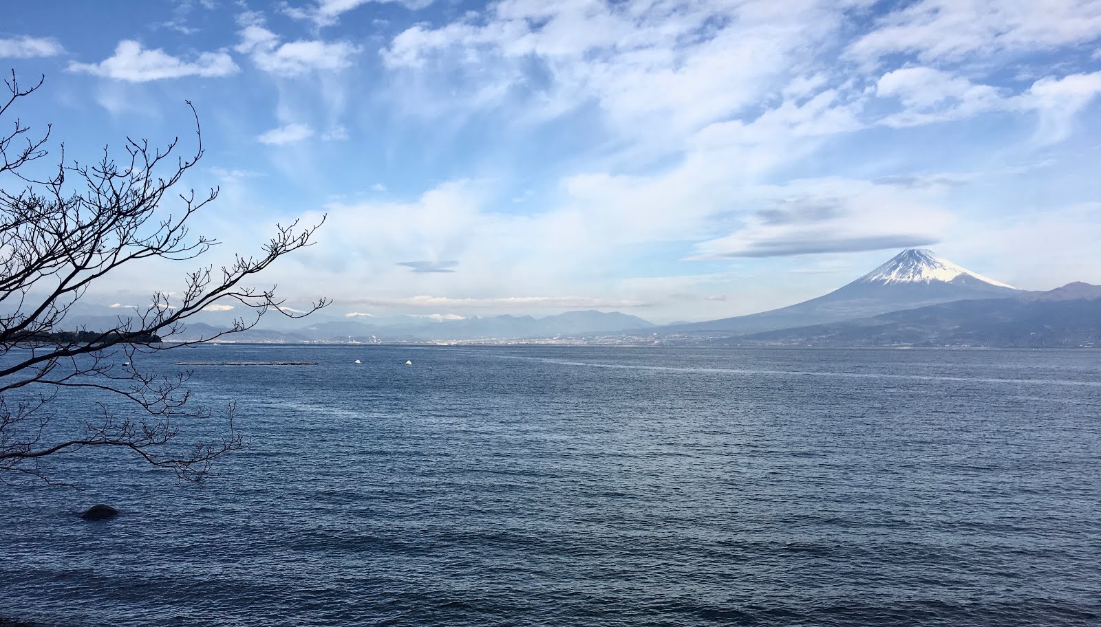
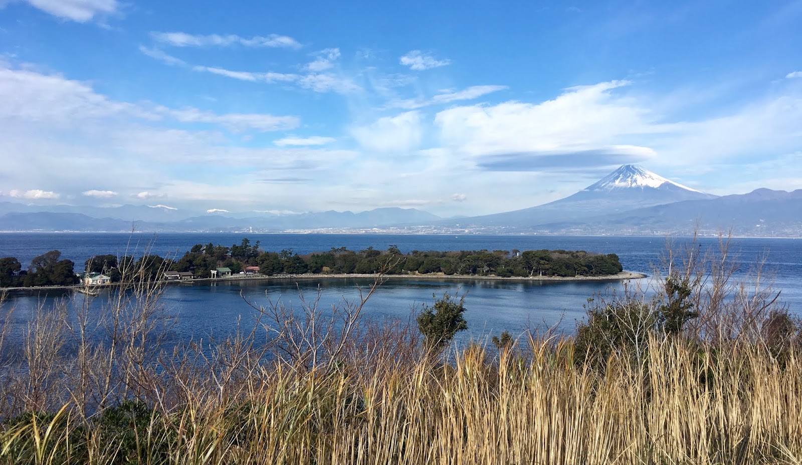
The rain stopped on the LONG descent from 875m elevation down to sea level, and by the time we got to Suruga Bay area we were riding on dry pavement and even got a bit of late afternoon sunlight. 
Jerome struggles with zip ties and a failing light bracket.

Looking from Numazu toward Izu.

Finally some lovely late afternoon weather around Numazu. Fuji visible, barely.

We slogged through heavy traffic around Mishima and onto the gradual climb up to Gotemba. This takes more than 25kms to climb up to 460m elevation, much of the climb at a 2-3% grade. The middle part of the climb was on a quiet road, and as we switched back to a main highway further up, the traffic had died down. We rode in fog and mist for awhile, but that cleared away near the top and for the descent down the East side of the hill toward Matsuda and Hadano.
Late night in Sagamihara after 270 kms or so.


After a somewhat unpleasant stretch on Route 246 alongside trucks still running on Saturday evening, I got to the last PC quiz point in Isehara and turned north onto local roads. Another 60kms of riding in the dark, quiet night, and it was back to the finish. The last 10+ kms from Oume/Hanno area back to Iruma seemed remarkably easy. Indeed, it was mostly a gradual downhill. Perhaps that helps explain my slow start, in the opposite direction?
Done just before 2AM.  ... I would be happier if we had finished around Midnight,
but was glad to at least finish, within the time limit.

Instead of the usual convenience store receipts, Saitama Audax used "quiz points" based upon mostly postboxes along the route. 
Quiz at Yamanakako - what time are weekday mail pickups? 

I reached the Yamanakako quiz point only 30 minutes before the cut off, thanks to my creeping start and climb up Doshi.  The subsequent checkpoints were only a little better, and eventually I finished with 1 hr and 7 minutes to the cutoff. This was the slowest I have ever done a 300km brevet. True, the course was not easy with plenty of climbing, and the rain slowed the pace a bit. 
Elevation profile. Lots of climbing in the first half especially. 3700m total logged
(vs 4800m elevation gain predicted via RidewithGPS)

But in truth, it was mostly not too hot nor too cold, and I did not suffer any serious mechanical issues. Not a single flat tire/tube. Once I re-lubed my dry chain after the rain stopped, I had no drivetrain issues. My brake pads were worn from the long, wet descents, but lasted to the finish. My lights worked. And I am sure that alone Jerome could have done the entire ride at least 3 hours faster than I managed. 
The Okayama 1200 and this, my only subsequent Audax event yet this year, prove that I have a long way to go to get back into ultra-endurance riding condition, to have any reasonable hope of again completing 1200km events. But it was a start. At least I could get through a 300km with no "significant" issues. Nothing hurt, not back nor neck nor butt nor feet nor hands. My only physical complaint was indigestion and some accompanying lower back (kidney?) pain, until a toilet break well into the ride (Gotemba?).
PBP is my goal for 2023, and I now need to set some interim goals for 2022, and plan enough brevets to help me get back some of the speed I had doing these only a few years ago. There is hope.

11 January 2019

"No Photos!" Ride on Nishi Izu Celebrating Fukuzawa-sensei's Birthday


January 10 is the birthday of Yukichi Fukuzawa, founder of the university where I teach and the gentleman whose visage adorns the 10,000 yen banknote. So the university is closed on January 10. Happy Birthday, Yukichi!

I have time conflicts and cannot ride this weekend, so I decided to seize the opportunity of the local holiday, ignore the stacks of papers to grade and other work not yet done, and instead take a training ride with a bit of climbing. I hopped the shinkansen from Shinagawa for the 45-50 minute trip to Mishima at the NW corner of Izu Peninsula. It seems like every time I go here, I get bogged down taking photos of Mt. Fuji in the distance across the bay. It is irresistible. It happened to me when I rode this coastline before Christmas, and every time I can remember before. So I have plenty of photos of Mt. Fuji from this route. Do I really need more of these photos? No! I need to FOCUS on getting in shape for Tasmania and PBP.

So today I was determined -- minimize the photo stops, get in a quick ride, if possible a loop out along the coast to Toi Onsen, then Route 136 east over the pass (well, not the real pass, but the tunnel at 500m elevation that cuts through the line of mountains above west Izu's coast), and the long gradual descent to Shuzenji, and back North along the Kano River to Numazu/Mishima, and get back to Tokyo mid- or late-afternoon!

I did quite well, really, for awhile. I was able to resist any photos for the first 25+ out of nearly 110 kms, until I stopped to remove my top layer jacket. This was not even a photo stop, right? It was a stop to remove excess clothing before the climbs to come. Doesn't count! And the photo was, well, spectacular, but not up to par for this course. Too little variation between the color of the water and the sky -- just different shades of blue, yawn -- too little snow on Fuji, nothing interesting on the water. I won't even post it in large size. If you read this blog, you've seen it before.

Then another quick stop for a bathroom break on a side-spur of a road, where the clouds and trees merited a photo. Also not a real photo stop. But the sky and trees were getting a bit more interesting.

Then I lost it. I took some photos briefly on the hill above Osezaki. One quick photo stop.


Then another one looking back after the first climb. Wow. I thought Fuji would be gone, around the corner from here, but there it was ... and an interesting foreground too, the village of Ita (井田).

Then more photos just after Heda. Last June (broken crankarm ride) and in December, I had not made it to this hill just past Heda ... and the mountain is perfectly framed ... and surely this is the last view of Fuji I would get from along the coast. So just for old times sake ...


Then I climbed more, longer hills on the 15kms between Heda and Toi. I was pretty much alone. The only roadies I had seen were far north and heading home to Numazu. I saw at most ten moving vehicles on this entire 15km stretch, mostly locals in "kei" trucks. As I emerged on the South side of one of the tunnels, a blast of wind hit me. There were whitecaps below -- and the wind and waves were coming not from within a protected bay, but straight from the Pacific to the South.

I remembered Assynt, the Rapha image film of hard men riding in rough weather in northern Scotland under dark clouds, rain spitting at them as the entire branding campaign "jumped the shark". I could almost hear the deep sonorous Scottish accent announcing "the shipping forecast ... there are warnings of gales". Could I, here on the rugged west Izu coastline, be livin' the Rapha dream lifestyle?  I checked my clothing. No Rapha. And even worse, the pavement was dry, and the wind quieted as I descended. Disappointed, I continued on.
Sun reflected on the ocean through a break in the clouds


A few kms before the center of Toi, there is another small town, Odoi. As I passed and rounded a corner toward Travellers' Point (旅人岬), the wind hit -- full force!  I was standing up and on the bike and barely advancing on the pedals. There was an old lady walking at the side of the road, leaning steeply into the wind as she edged ahead slowly. .... and I edged past her on my bicycle. We silently acknowledged each other's efforts. Now that was more like it! And I remembered, yes, under my shoes, inside my "windblock" shoe liners, yes, I was wearing Rapha socks! Ahhhh.

Anyway, soon I was at Toi Onsen. I checked out the foot bath, the tourist info place (typically, they did not steer me toward any one restaurant, but just gave me a map and circled the places they thought were open). I ended up getting a rather basic and slightly expensive "mixed fry" teishoku lunch. This stop put me way behind schedule.


The climb was steeper than I remembered. The last time I did this climb was with Steve Ridgely back in April 2015 on the R Tokyo 400km brevet. That time it was already dark, and I was exhausted, so it seemed like a hard climb. This time it was mid-afternoon daylight, the road was dry, and there was even a tail wind at points. Yet, it was still a hard climb. 500 meters up over 8kms. There is some variation, with a few stretches in the 10% range and some nearly flat. Anyway,  it was good exercise.
Starker than in April 2015 when many trees on the hillside were flowering.
The east side of the hill is far more gradual.

I could enjoy a nice 13km descent to Baird Beer's brewery along the river just south of Shuzenji, where I stopped off to say hello to my friend from the Chicago alums group, Baird business manager John C. My plan for Olympic cycling involves the velodrome at Shuzenji and the Baird Beer brewery tap room, restaurant and campsite in the valley nearby. Further behind schedule.

Bike leaning

River and very blue sky without bike leaning
Then, inevitably, irresistibly, Mt. Fuji showed a different face, with different foreground, light, clouds, pastel instead of deep blue sky, ... and I took even more photos en route back to Mishima!

Finally, I hopped the train and was back in Tokyo just after 6PM.


Strava track available here (minus the first couple kms).

27 December 2018

Exploring NW Izu -- 2018 December version!

Mt Fuji from Numazu, near the mount of the Kanogawa (Kano River)
I love cycling Nishi Izu. The road along the coast ... all the way from Numazu to Minami Izu and Shimoda ... belongs in any proper collection of "best rides" in the entire world for road cyclists.
Mt Fuji from above Osezaki
Please, friends from outside Japan, come and ride it, and tell me if you disagree:  Low traffic, spectacular views of Mt. Fuji and appropriately dramatic coastline, mikan (citrus) orchards, small, quaint towns with fishing and yacht harbors, onsen (even a public "foot bath" at Toi Onsen), special local crab at Heda harbor, and on and on.

Last December I did the ride to Shimoda. And it is a very long and hard day to go from Mishima/Numazu through to Shimoda and then return by train to Tokyo ... really it would be better done as an overnight trip, with an onsen ryokan as the reward for cycling up and down all the hills on the further stretches of the coast. In May tried a shorter version ... but a broken crankarm (I must be too strong for SRAM Rival?!) meant a long way back out from Heda to Shuzenji by taxi after a missed bus then a train home.Today I again tried a shorter version, 100kms, but without much climbing and at a relaxed pace.
My route -- barely scratches the surface.


Mt Fuji from one of many small harbors on the Suruga Bay

First embankment ride of the trip.

The mouth of the Kanogawa
Birds (geese, ducks, others) at an interspecies concrete resting place with view of Fuji
So I am still looking for ways to do this as a day trip more easily, and I found one. I did not leave Shinagawa until a 936AM Kodama shinkansen, which dropped me off at Mishima an hour later (4000 yen or about $35 each way). Even with a shopping stop to pick up some ceramics at a place that caught my eye, I was back at the station shortly after dark and in Tokyo around 6PM.

Working harbor at San-no-Ura
This boat was in my photos last year also! Cannot resist the framing of Fuji with the hills on left and right of the harbor.
After de-rinko-ing the bike at Mishima, I made my way through the crowded town and eventually to near the mouth of the Kanogawa in Numazu. I had planned to go up the Kanogawa along the path atop an embankment, then go back to the coast at Kuchino (口野) where the river's 口野放水路 cuts through the hills and allows access, but having just ridden DOWN the river embankment the last few kilometers, I decided instead to take the coast road (National Route 414) from there. I knew it was a congested, no shoulder road, but I've ridden it before and was comfortable that in a few kilometers I would be free of the traffic.


.
The joy begins at Kuchino Hou-Sui-Ro 口野放水路 intersection, where National Route 414 turns inland, and Shizuoka Route 17 continues along the coast. I stopped at the Numazu Cycle Station at the former Shizu-ura Higashi Elementary School ... but it was closed.

Still, this facility is part of Numazu's efforts to promote cycling tourism, and has the benefit of being a great place to park a car if you wanted to drive from Tokyo and ride from here. Because I was on their list from having joined a Shizuoka Audax brevet that started here last January (and headed NW/West to Fujieda and back), they sent me a map of cycle trails and proposed routes in this part of Izu. It was what gave me the idea of taking the embankment trail.

Anyway, I rode as far south/west on the coastline as the hill between Osezaki and Heda. Having climbed to several hundred meters elevation and gone through the tunnel at the top, I decided to turn around and go back down to the North, as I knew that if I went down the hill again to the South, the routes to central Izu further south all involved going over the mountains. I retraced my route as far as Uchiura Mito. (内浦三津)

From there I did a short climb over a low hill, and through a short tunnel, and could descend into the central Izu valley of the Kanogawa, emerging near the bottom of the ropeway that goes to the top of Mt. Katsuragi. From here I took a road that hugged the eastern side of the valley, until it veered left and brought me to the Kanogawa.
Looking back at Uchiura Mito ... only a bit more to the tunnel through the hill.
Crossing the river, I joined the path on the embankment, and took it South, up the gradual valley. I've taken the road up this valley before, and I can say that the path is far better. No traffic! Wide, flat, smooth, with minimal interruptions as far as it went. After about 5 kms, I switched to the road where the path seemed to end ... but on my return, I realized that the path in fact continued: it re-started and went several kms further, only a few hundred meters of interruption. At many places, I could see heavy traffic on the highways, standing in lines at each signal. I was glad to be on the bicycle, and on the path instead of the road.

After Shuzenji Station, I somehow ended up going up a tributary -- the Omi River -- and turned around after 3PM. I thought about continuing up the Kano River after doubling back, maybe a stop to say hi at Baird Beer, But I already have some beer in the fridge at home, and cannot drink on this kind of ride. And the day was getting short (actually it was cloudy and quite ominous looking weather) so I just headed to the North and toward the station at Mishima. This time, I stayed on the path along the embankment for a full 20 kilometers of beautiful, stress-free riding. In the future, the path is my way from Numazu/Mishima into central Izu.

I will be back again soon! Next time, I will push further -- through to Toi onsen, climb over the pass and come back down the Kanogawa -- adding another maybe 30 kms and some serious hills -- for an ideal training ride in winter when the mountains north and west of Kanto remain icy.
Not much daylight left!