 |
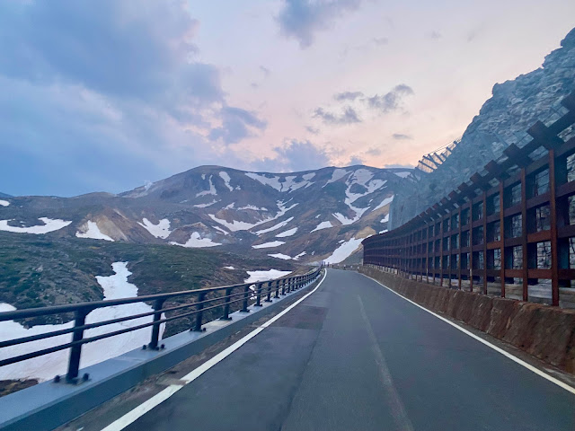
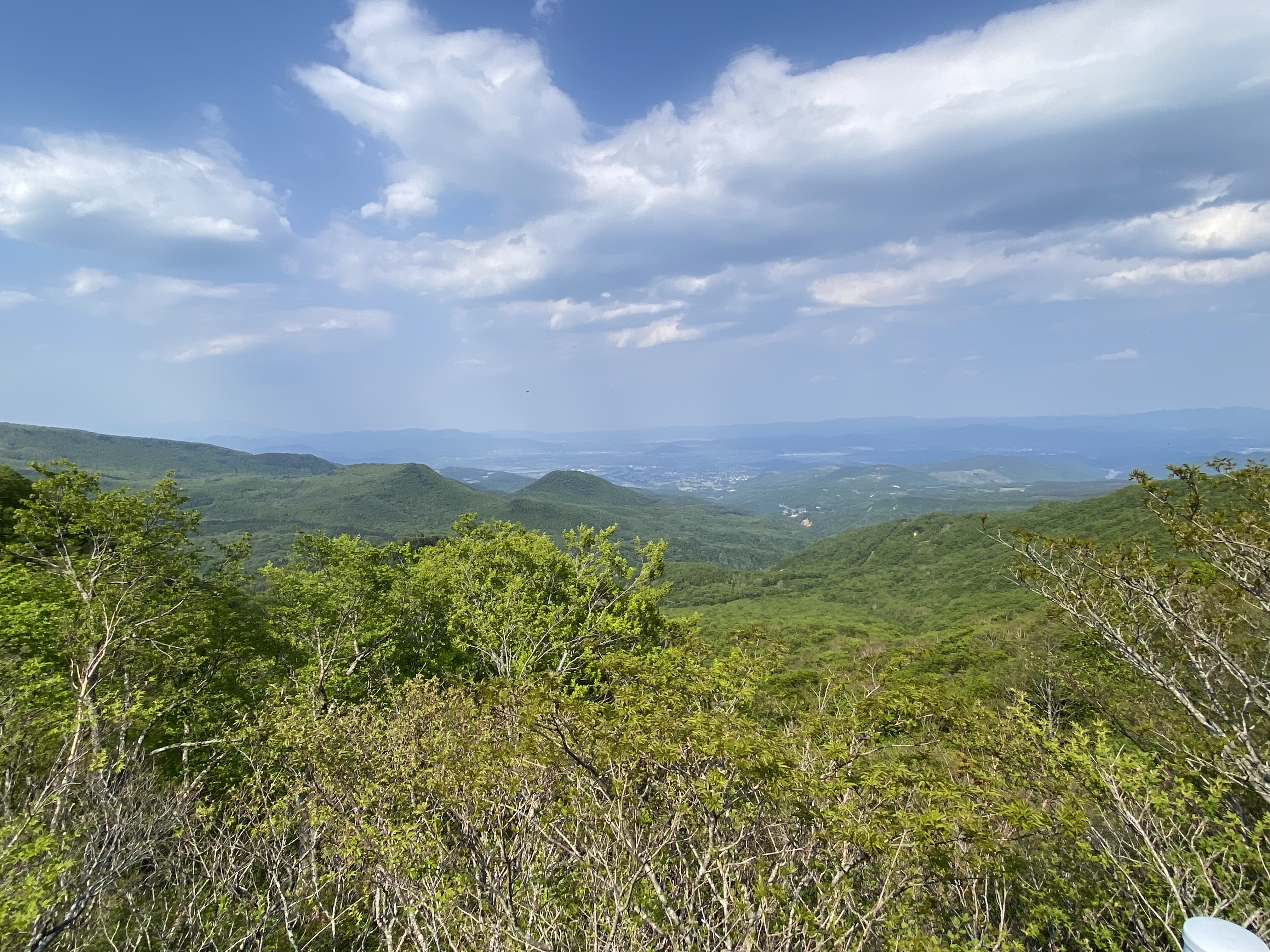
| On the climb from Fukushima-shi to Jododaira |
I wanted to try to get in some more multi-day rides before Cascade 1400, so had blocked off May 19-21 and one more weekend in June to try and do so. For the first of them, I thought I would try one of the
many SR600 rides now available in Japan. Back when I did the SR600 Fuji in 2015, it was one of only 3 available. I tried one of the others -- Nihon Alps -- twice, but rainstorms and exhaustion defeated me both times. Now there are 18 courses within Japan.
Why so many now? Well, about 4 or 5 years ago, the rules were changed. A standard 600km brevet has a 40 hour time limit. An SR600 is a "permanent" 600km brevet with more than 10,000 meters of elevation gain -- a very mountainous course. Until the rule change, an SR600 had a time limit of 48 hours plus an extra 30 minutes of time for each additional 500m of elevation gain over 10,000 meters. SR600 Fuji had a 52 hour time limit, if memory serves. This was complicated to administer, and the massive climbs made it very challenging for many riders to complete these courses, more so than other Audax time limits. So the Audax organization changed to a flat 60 hour limit on all SR600s. Of course, in Japan there are lots and lots of mountains, and lots of roads over them, so the SR600 course options are plentiful, and designated courses have proliferated.
I decided to ride the Fukushima course for a few reasons. First, it is easily accessible by train - shinkansen to Koriyama, less than 90 minutes from Tokyo Station. Second, it looked as if it offered a wide range of riding and scenery -- dense coastal forest, bucolic farmland, Alpine-like passes, lakes, rice farming areas, and on and on. This reflects the diversity that is Fukushima Prefecture. Third, I wanted to both "support" Fukushima prefecture in a small way, and to see how it is doing, eleven years after the tsunami and nuclear disaster. Indeed, the AR Nihonbashi organizer site said one reason they decided to make this course was to support some cyclotourism in Fukushima.
 |
| SR600 Fukushima course |
 |
| SR600 Fukushima elevation profile. Highpoint of 1622m. All the big mountains are in the first half. |
The ride satisfied all these expectations and many more. The vast bulk of the ride was on low or no-traffic routes, and there were long stretches in, for Japan, quite wild areas. More than usual, planning was required to identify convenience stores and other likely-to-be-open stores or restaurants along the route, to avoid running out of food or water.
I had a commitment later on Sunday, and a work call on Thursday morning from 1030-11AM, so decided to take the work call from outside Koriyama Station and then start at 11:10AM. The first hundred kilometers of the route included the longest climb and also the third longest, and it looked as if, by riding the 227kms to Aizu Wakamatsu, I would notch up around 5000 meters of elevation gain. That seemed a plenty ambitious goal for day one. I booked a business hotel.
On day two, I would plan to start a bit earlier and ride 287kms to Iwaki, with another nearly 5000 meters of elevation gain. Again, the second longest climb of the event was in the first part of the day, there was another smaller climb out of Yonezawa, and then a long downhill to Fukushima and what looked like typical Japanese up-and-down the rest of the way to Iwaki, but no long climbs. Again, it seemed doable. I booked a business hotel in Iwaki for the second night. Then I would have less than 100kms and under 2000m of elevation gain for the last day, again with the main climb in the early part of the ride. If I could stick to my schedule, I would finish on Saturday afternoon, with 6-8 hours to spare and in time for the train home and a hot bath before bed.

The weather was spectacular on Thursday, even a bit warmer than one would like, as I left Koriyama on schedule. Heading out of the city to the west, I thought I might be in Utsunomiya, or Mito, or Kofu, or Takasaki, Maebashi, or Ashikaga, or maybe Kofu, or Kashiwa, or any of dozens of other small regional cities north of Tokyo as I passed a
Cainz Home Center, an
Aoki Menswear, and a gaggle of other big box and chain stores.
But in a few kilometers the sprawl ended and I was on a rural highway heading west. Not so much farther along, I turned right onto the Bonnari Green Line and started a gradual climb that eventually stepped up to the 6-8% range.
It was a beautiful day and the heat (~27C) in Koriyama quickly dissipated once I got up onto the climb. After one stop for some fuel in the form of an energy bar, plus bathroom break, I could climb steadily to the top. There was some construction on the road, but so little traffic that I got waved through and never needed to stop and wait for opposing traffic.
 |
| From Bonari Pass |
 |
| Starting the descent after Bonari Pass |
Before I knew it, I was at Bonari Pass,
site of a battle in 1868 between the Meiji restoration government forces and the rear-enders of the shogunate, which also served as the SR600's PC2. I could see higher mountains in the distance, with large patches of snow visible. The elevation was just under 1000m.
The road descended to the north until a T intersection with National Route 115 in an area that had some resorts, sobaya and restaurants, onsen, and basic services. My route turned right/east and started the next climb. This climb would go from around 750m to 1250m, along Route 115 then north on Prefectural Route 70 until another right turn that started an incredibly lovely descent toward Fukushima city.
 |
At the turn off from Pref Route 70 to Pref Route 30, approx elev 1250.
I came up the slope visible in the photo. |
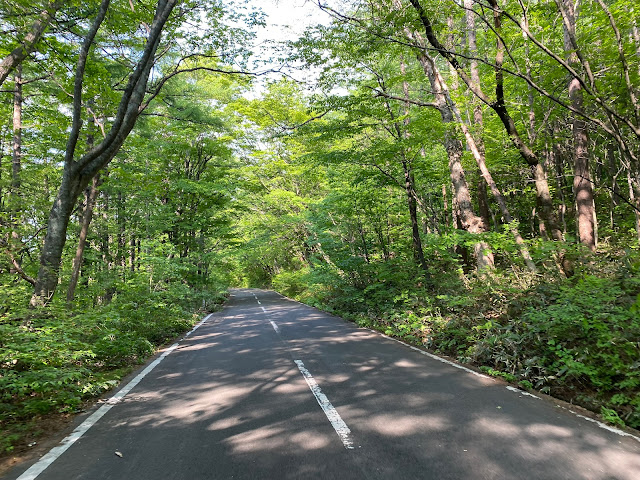
The descent was nearly 1000m elevation loss, much of it on a beautiful, low/no traffic route and with forests for shade. I felt blessed by the weather as the breeze of my movement cooled me. The descent had plenty of twists and turns, but also did not require me to sit on my brakes much -- ideal! There were a few places where beautiful, deserted Pref Route 30 crossed National Route 115 ... only for the last few kilometers before the SR600 route turned left did I need to ride on the main road.
 |
| Early on the Route 30 descent toward Fukushima city |
 |
| Snow fields beside the road |
 |
| View as I descend |
 |
| It doesn't get any better than this. |
I stopped at a 7-11 store for some food. This was the first convenience store since well before starting the Bonnari climb, just before the route turned left. It was now 40 minutes after 3PM, my arrival target time. Technically, I had entered Fukushima city at some point on the descent, but I was turning onto a "wide area agricultural road" and was still somewhere on the western foothills about the city. All the better, as I would need to climb back up the same mountain range for the big climb of the day. To my modest dismay, the agricultural road continued to head gradually downhill for a few kilometers until PC3, at a memorial stone of some kind just outside of Azuma Sports Park. The cue sheet and brevet card did not contain details of the memorial location, but I remembered one of the ride descriptions had said something about it being off of the road. I had already turned left beyond the park ... but went back, crossed the road, entered the park and looked around. I took a few photos to prove I had been there, hoping they would suffice if I could not find the actual desired PC photo spot. As I was leaving and returning to the road, there it was!
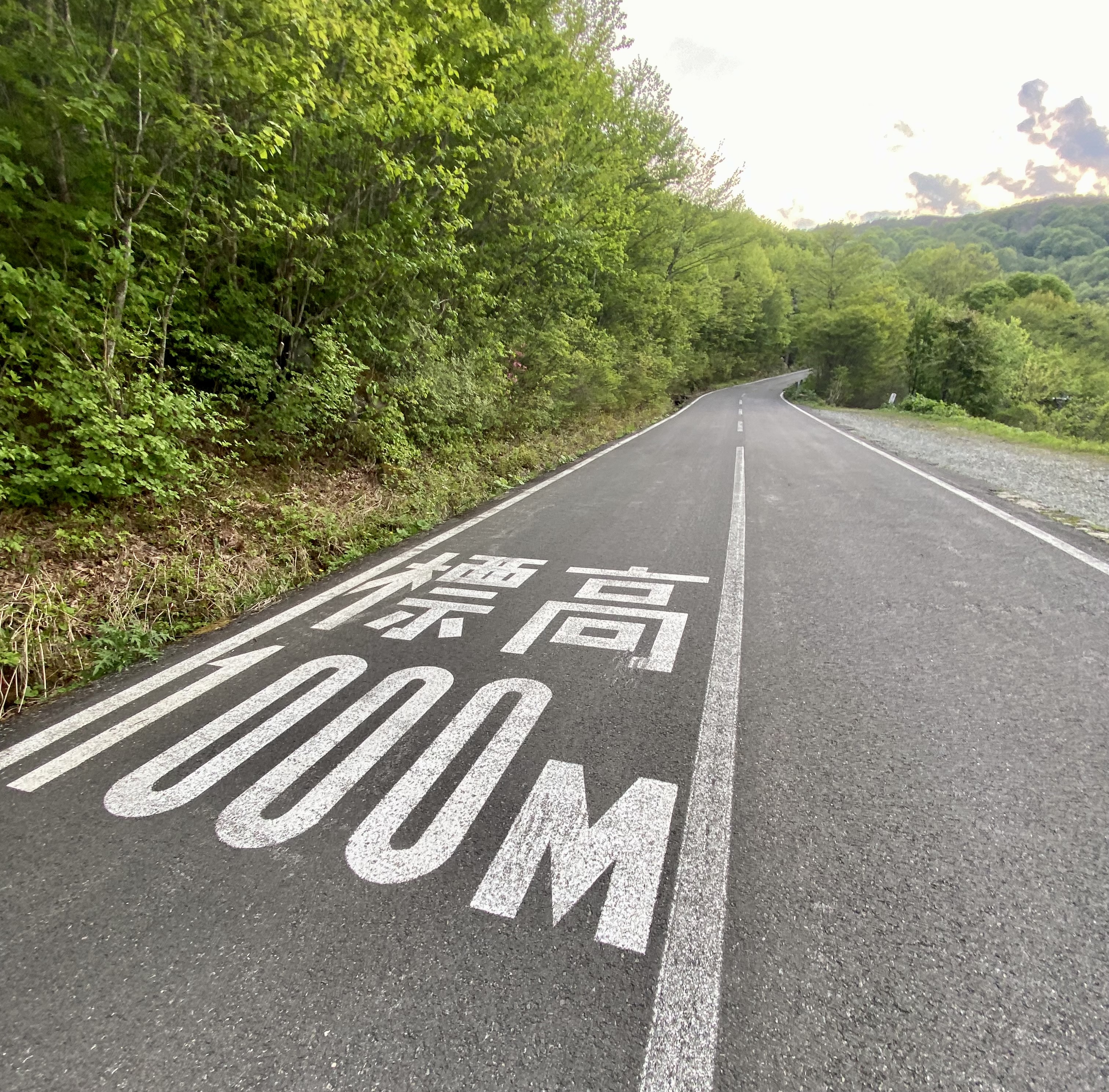
Back on the bike, the road hit its low point and after a left turn onto Pref Route 70 (yes, the same road I had been on previously), started my longest climb of the event. I was well under 300m elevation and would go to 1622m. Maybe 1400m elevation gain in total, ... having already done that much so far. It was hot, and humid, and the road quickly became steep.
I was glad that I had (for me) ultra low gearing with a 36 cog in the rear and 48-33 chainrings. But I was still grinding up the hill in a low cadence, barely faster than walking. I could tell it would be a long, long climb.
 |
| Looking down from just above Takayu Onsen, most of which is 800-900m elevation. |
 |
| Still a long long way to go, but at least it is getting cooler here! |
 |
| Reminds one of the climb up Shirane-kosan to Shibu Toge, above Kusatsu? |
I tried to take the hill in 200m elevation increments ... not allowing myself to rest until I had climbed at least 200m from the last rest. I felt tightness at the back of my knee on my left leg. I worried that I might pull something and end my ride -- it has never happened to me, but there is always a first time. I now read that this was probably not my hamstring, but
the sciatic nerve that goes from the lower back through the legs. That would make sense, as the bike I was using, Voyage Voyage, has a more aggressive (lower) front end and so requires more stretch of my back than the RAMAX or the Sky Blue Parlee.
In any event, it was a long and slow ascent. I knew that once I got to the top, I would be done with the hardest climb of the entire SR600, even if not yet 20% through the distance. The road was deserted in the fading afternoon light. It was not cold, but the wind was coming up as I reached exposed areas of the upper slopes. I was very glad to have the wind, however, as I started to pass signs warning about poisonous volcanic gases. Do not park your car! Keep your windows closed! No suggestions for what cyclists should do ... but I was not thinking about filing a complaint since the obvious Japanese bureaucratic response would be to close the road to us. At least today any poison gases would be sent soaring into the stratosphere by the gusty wind. These signs, as well as the scenery, contributed to a strong resemblance to the climb above Kusatsu!
 |
| The PC is just over that shoulder above on the right. |
 |
| At Jododaira ... a flat area before the last little climb of the afternoon/early evening. |
 |
The lighted building is a restroom ... they leave the lights on I guess.
No sign of anyone around associated with the little "kei" car in the parking lot. |
 |
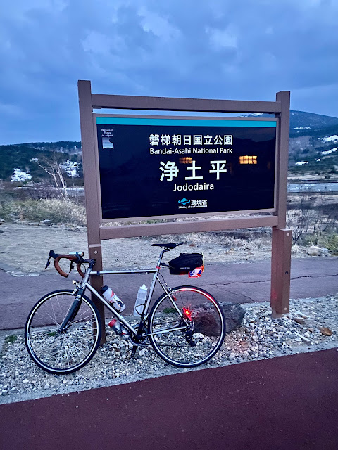
| At the highpoint for the SR600. |
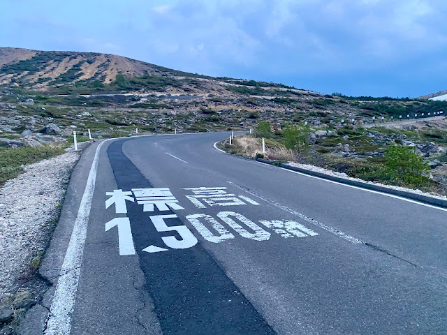
As I passed 1500m elevation and finally approached the rest area at Jododaira, the light continued to fade. I had not seen a car on the road for at least 20 minutes, and then only one had passed me, going down, in the last hour. I guess no one is up here at night. It was 7:08PM at Jododaira. I had hoped to arrive by 6:00-6:30PM, so I guess I was only a bit behind schedule. But it was an important bit in terms of not getting down the first part of the descent before dark.
I quickly continued on through the flat area at Jododaira and up another short climb and through some bends in the road ... to a point clearly marked as the top of the Skyline route. As I put on some warmer clothing for the descent, one car DID pass me, a rugged looking SUV. But that was the only human I saw until after I had descend back down to the intersection of Routes 70 and 30 (completing my "loop" and even beyond.
Once the descent started, the road twisted back and forth. My light beam was not wide enough to see "around" the corners, so I took it nice and slow. A jackrabbit jumped across the road in front of me, lit bright white in my headlight. Wow, that was a FAST rabbit! I had seen three monkeys earlier. And it would not have been surprising to come across deer, bear, inoshishi, tanuki, or kamoshika, in this area. A fall off the bike from a pothole or to avoid an animal would have been disastrous, with no expectation of cellphone coverage to call for help or rescue until morning. So I took it easy.
I was running a bit low on water, but I knew that my route would take me down onto Route 115 and near the resort/onsen area I had passed this morning after Bonari Pass, so hoped I could stop there.
I was mistaken. The SR600 route turned off National Route 115 before descending to those sobaya and other shops. Instead, it turned off onto a continuation of Pref Route 70, now called the Bandai Azuma Lake Line, and proceeded through more wild, forested, and largely deserted country. There were plenty of ups and downs, though no major climbs, until I finally arrived at the Ura Bandai resort area between Lake Onogawa and Lake Hibara. At around 139kms there was finally ... a convenience store! I had rationed my water supply and was feeling a bit weak and dehydrated. It was already almost 10PM and I had still had another 88kms to go to my hotel! I ate some pasta, drank a coffee for the caffeine, stocked up on snacks and filled my water bottles.
 |
| Urgent news for the residents: Bear sighting nearby earlier in the month ... |
After the stop, I passed some what looked like fairly luxurious resorts, fancy cars in the parking lots, welcoming warm lights inside. Then after a few kms I turned off of Route 115 and onto prefectural route 64 for the climb over a shoulder of Mt. Bandai. This climb was not steep, and would have been easy if I had been fresh. I was not. It topped out at 1200m elevation or so, then started a long descent toward the area around Lake Inawashiro. But I still needed to watch for animals. I switched on my reserve battery powered light with its widest possible beam to get some light outside the frame of my main dynamo-powered light (which I will swap out for one with a wider beam before my next adventure on this bike!).
But I also needed to find the next checkpoint. It was supposed to be a signboard somewhere by the road. But there were numerous parking areas, and I was descending in near pitch dark. The worst scenario I could imagine would be to miss the PC and need to climb back up this hill. I pulled into several parking areas before I finally got to the one that had the signboard I needed. It was supposed to be a viewpoint for Mt. Bandai. Yes, there was the mountain, looming above.
 |
| Mt Bandai at 11:30PM on a dark night the moon not yet visible. |
I continued down the hill, then headed east around the northern side of Inawashiro-ko. I could make good time here, finally, now that I was on relatively flat ground. if I just turned right and headed downhill, I would have gotten to my hotel in Aizu Wakamatsu in less than an hour. But instead the course went East then South, around the entire Inawashiro-ko, and I was still at least 60-65kms from bed.
 |
A big flooded rice field south of Lake Inawashiro
|
After yet one more 7-11 stop at Shidahama on the eastern shore of the lake, I continued around to the southern shore, one last PC photo by a monument of some kind, then the road narrowed and became a kind of forest road, climbing through hills along the edge of the lake. The road surface was of mixed quality, almost gravel in places, and covered with leaves, sticks, or stones in others. It twisted and turned and I slowed down. At least I was now at 550m elevation instead of 1500-1600m, so even if I had gotten stuck for a few hours I would not worry about exposure, but I needed to be careful if I wanted to avoid a problem that would end my ride. The climbs were very short but sometimes steep. Rounding one corner I came face to face with a raccoon, only a few meters away and staring into my front light. It looked white in the bright beam, and terrified. It jumped to the side and raced away as I passed. I've seen raccoons (tanuki) slink away at night before, but never confronted directly nor jump like that.
It was after 3AM as I started the last, relatively short climb to a ridge top before the descent to Aizu Wakamatsu. The moon was out now and providing a bit of light -- it has appeared after midnight but been blocked by clouds until the sky cleared a few hours later. On this climb, I wished for a tunnel through the ridge, but there was none. Instead, the road made it to the top of the ridge and traveled under wind turbines before another really lovely descent -- from almost 900m to around 200m elevation. I took a PC photo or two in front of the Tsurugajo castle in Aizu, first light having appeared in the sky during my descent, and it now after 4AM.
I went to find my hotel. I would live to fight again another day.


No comments:
Post a Comment