

I had a good feeling at the beginning of the 300k ride. I had been exhausted on the 200k, accumulated jet lag from the Portland-Tokyo-Sydney-Hobart economy class trip with a whirlwind 48 hours in Tokyo and afternoon of bodysurfing and eating near Sydney. But completion of one ride, and two more nights of good rest, with beautiful cool, clear weather, had me eager to ride.
Also, the 200k was, for me, a kind of "warm up". I had already done a 200k in January, and main goal for me this week was to qualify for PBP, or at least get as many as possible of the 300, 400 and 600k rides done. I knew the 600k would be very hard, but if I could complete the 300k and 400k rides, I would consider the trip a success.
The day before, Mark Thomas of Seattle showed some of us an iPhone app called "Epic Ride Weather". If you link it to your ridewithgps.com route, input your anticipated overall speed (including rest stops), and your start time, you get a chart of temperature, precipitation forecast, the elevation profile, and most important, a map with wind arrows showing the likely strength and direction of the wind for your entire ride. This app was extremely helpful during the rest of the Tasmania trip -- in giving me the courage to leave in my drop bag gear like rain pants and my coldest weather clothes, as totally unnecessary. Before sleeping, I checked the app and confirmed we would expect dry weather, hot in the afternoon, with relatively stiff headwinds during the 100k+ stretch heading near due west the first half of the ride.
 |
| One of the Aussie riders had this amusing reflective vest ... designed with its check pattern to fool a casual glancing driver into thinking it is a "police" vest. No, just a "polite" vest. |
 |
| And plenty reflective. |
 |
| My last view of Freycinet Peninsula. Glorious in the dawn pre-sunrise, with a vineyard in the foreground. |
I was still alone as I climbed the north side of "Cherry Tree Hill" (still no cherry tree in evidence). I stopped to take a photo of a spectacular vista at dawn, and could see a few lights of cycles behind me starting the climb, at least 4-5 minutes back. Again, I was starting too fast. ... but no reason to slow down descending the other side of the hill, and the wind was not noticeable as I pushed on, all the way to the right turn off the main highway and onto Lake Leake road.
 |
| Lots of bumps in the flat sections that don't show up on a 300k profile. My Wahoo GPS showed 3500m of elev gain; actual was around 3200-3300m. |
 |
| That is a climb from sea level to 600m elevation ahead ... though you wouldn't know it! |
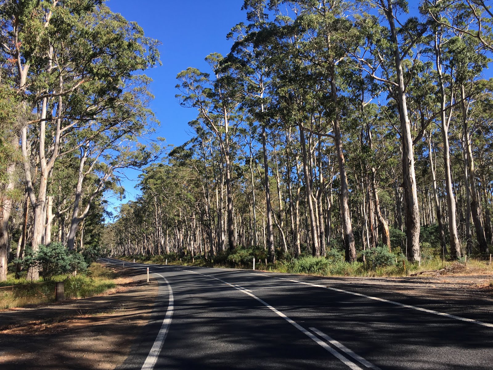 |
| Glorious eucalyptus forest under blue skies after the Lake Leake control. |
 |
| Near Campbell Town |

Eventually I slowed to a crawl in the headwind. Soon Tom (a government economist in Canberra and PBP veteran ... my roommate in Deloraine) and Fred pulled up. Tom suggested I work with them, which I did for the next 30-40km of the ride nearly to Cressy.
After another stop in Cressy, I ended up with Fred and Errol heading north toward Longfort and down the hill into Launceston. I wanted to call it "Lance - town" (hey, it has a bunch of bike shops, and the Velo Vineyard is just out of town 10kms or so to the NW), but the locals tell me it is pronounced "Lon-Chess-Ton", and I got a somewhat chilly reaction when I voiced my "Lance-Town" idea. I guess Lance is still a dirty word in cycling circles.
After a rest on a grassy triangle of park (at my insistence), we headed out of town to the NW on a major road, the A7. It was after-school rush hour, with lots and lots of cars, and massive private tour buses that were serving as school buses. The buses were particularly rude. One pulled out in front of me forcing me to slam on my brakes. Others roared by. But before long, at Exeter, we left the A7 for a much quieter road along the beautiful inlet that runs from the coast all the way to Launceston. We stopped at a hotel / bar for something cold (and non-alcoholic) to drink. Tom had rejoined, then Pauline arrived. After we departed, Tom and Fred went ahead, and I rode with Errol and Pauline. Soon my stomach acted up a bit, and we stopped to rest again and enjoy the view. It was a lovely afternoon ... but miles to go before we could sleep.
 |
| Looking back toward Launceston |
 |
| Pauline rests -- trying her first 300km ride ever |
 |
| Errol, the veteran rider, had committed to see that Pauline made it to the finish |
 |
| Beaconsfield control - Tom, Fred, Rick, Catherine, and my feet |
Andrew warned us that there were hills ahead. Deloraine was not more than 200-300 meters elevation. But Andrew warned us that we had at least 600 meters of climbing to go - up, up, up, down, up, down, up ... over the remaining 65km. My Wahoo ride track showed nearly 1000 meters climbing on this stretch.
But it was a glorious last stretch.
It was 7PM or so, and the deadline was 1AM. Even going slowly we could finish easily in 3 or 4 hours, with 2 or 3 to spare. There was no reason to hurry. I let others go ahead and decided that I would take it easy, already trying my best ... after the top of the first hill, to make it a "recovery ride" with a view to the 400k two days later. The sun was low in the sky, the countryside was beautiful, the grazing animals looked happy and well-fed. The farms looked prosperous. This reminded me of dusk some dusk rides in Japan through comfortable farmland nestled in the hills -- satoyama - with bubbling streams and lights beckoning from farmhouse windows. Scott zoomed by, and after a few more steep "dips", he was gone.
I caught up Mark as he rode back up a seep hill to get a photo of some scarecrow-like figures perched on equipment at the entrance to a farm. He lent me his lockring wrench so I could firmly tighten my couplers, one of which had come loose. He was quickly far ahead, rejoining his posse.
 |
| Mark's group of four just ahead, and Pauline, Errol and Fred at the near the top of this little 10% rise. |
 |
| Looking back toward Beaconsfield |
 |
| The moon creeps over the horizon. |
 |
| Brilliant landscape lit by the moon. |
 |
| Haunting moonscape. |
I passed Errol, Fred and Pauline, who were pulled over at a restroom and adding clothing. I could see Mark's group ahead, but could not approach them. Soon Fred again passed by me. Errol was sticking back with Pauline, who had said she is not comfortable riding alone at night (and had never ridden further than 200km before).
As I made a right turn onto Birralee Road, Andrew was parked on the shoulder watching over us. I pulled up and knocked on his car window. "Thank you!", I said. "What a wonderful route! And riding in the early evening cool and quiet, in this environment ... it just doesn't get any better than this!!!"
From here, the ups and downs were much more gradual. Shortly before entering Deloraine Tara zoomed by. I could not keep up, and she disappeared up the street ahead. ... I remembered that our lodgings were at the far end of town, out of town, from our pre-ride briefing.
After checking in and a quick shower, I headed over the the restaurant for dinner, a beer, and a banana split reward.


No comments:
Post a Comment