Showing posts with label Mikuni. Show all posts

01 April 2019

My Day to Ride

On lower Doshimichi. Clouds to the East at sunset.
On Sunday I woke too late to join the Tokyo Cranks annual sakura viewing ride. But I had been hesitant about going in any event. Today I wanted to ride to beautiful places, and up some real climbs, and the Cranks' plan to see sakura en route to Koganei Park, then get coffee nearby, would have wrapped up late morning with me at least 25kms from any the entrance to mountains, leaving only a half day to ride out of Takao, Musashi Itsukaichi, or Oume.
The reward for a climb.
Yes, I wanted to view sakura, but today I wanted to climb, and I wanted to see beautiful scenery. And I wanted the freedom to go where the weather was good, to alter my plan as the mood struck me. Freedom; a good sleep instead of the usual early alarm to meet others; no set course, no Audax time limits; and no afternoon or evening plans that would make me watch time carefully.

I decided to go to Odawara and try the Ashigara Pass climb that ice and snow had prevented me from completing last year. I have only been over it once, coming from the other direction.

Path along the Sakagawa. 
I packed my rinko bag and a thin rain/wind shell and headed for Shinagawa. Out the door at 830AM; at Shinagawa and starting to pack the bike at 835AM; heading into the station at 842AM; and on the platform and into the train at 847AM. I took a Tokaido local since I would have needed to wait until 9:04 for the next Kodama, and I enjoyed the flexibility to pick my station.

Kamomiya was a sleepy local station with flat, easy access roads through mixed farm, residential, industrial areas to get to the Sakagawa, which I remembered had a path I could ride up to get very near to the Ashigara climb. I thought about just riding on the roads, which had little traffic on Sunday morning, but the path and river seemed more consistent with a sakura ride, even if slower.


The sakura were starting to blossom at points along the Sakagawa, but still early. The peak will be over the coming week here as in most of Kanto.

I had not planned my route, but decided to try to stay off the main road and take a short cut up the first part of the hill and merge into Pref. Route 78. Looking at the map now, I see that Route 726 would have been much more direct. And I made a wrong turn, taking a lovely quiet local road up the hill past the Asahi Beer brewery (which, by the way, was hidden away down the hill, and had some beautiful sakura planted along the road in front). The road ended abruptly.
Glad I am not driving or the lack of road would be a serious obstacle.


My work in solar PV development trained me to find the path through places like this.
There always is a path, even if just a footpath a meter wide or so.
There were farms here, nestled in the valley along a stream. I carried my bike down the steps, walked along some paths between fields, waving at the few farmers I saw working on their fields. In a few hundred meters there was a concrete path. I took this until I finally returned to a real road and then onto Route 78 and the lower part of the climb.


The scenery was spectacular. Lots of photo stops. At one, I chatted with a local who had come out from across the street and was enjoying a grove of sakura surrounded by yellow na-no-hana. He asked if I was going to Ashigara Pass. Well, I was not sure. I said, perhaps Ashigara Pass then Mikuni Pass/Yamanakako/Doshi Michi. Or I might go over the closed rindo to Kintoki Shrine and Sengokuhara, then Hakone Pass and along the skyline and down to Atami, or west to Mishima. Or maybe Ashigara Pass then back down the valley along Rte 76 -- parallel to Rte 246 -- and then west to Hadano and home via Yabitsu Pass.

In the end, I decided to avoid Hakone and its traffic, and stick to the plan to do the Ashigara climb. As I had last year, I saw many trail runners going up and down this hill -- but only a few other cyclists. This must be a mecca for trail runners, the way that Yabitsu Pass and Tomin-no-Mori are for cyclists.
Kintaro always wears a top with the character "kin" (gold).
... as if I were always to wear a shirt with a big "D" on it.


At various points along the road there are signposts pointing to a path labeled 足柄古道 or Ashigara Ancient Road. Indeed, Ashigara Pass along the Tokaido is mentioned in the Manyoushu (万葉集) from the 8th century. It was later replaced as the "main" route by Hakone, and the sense that this is an ancient place is quite strong. The mythical boy hero, Kintaro, was said to be raised by a witch queen who lived up here on Mt. Ashigara. And the story of Kintaro, the boy of super-human strength, is apparently based upon a real person. At the entrance to the shrine at the top, there was a statue of Kintaro, with his hammer, riding a friendly looking bear cub. In fact, the bear statue reminded me of a wombat!


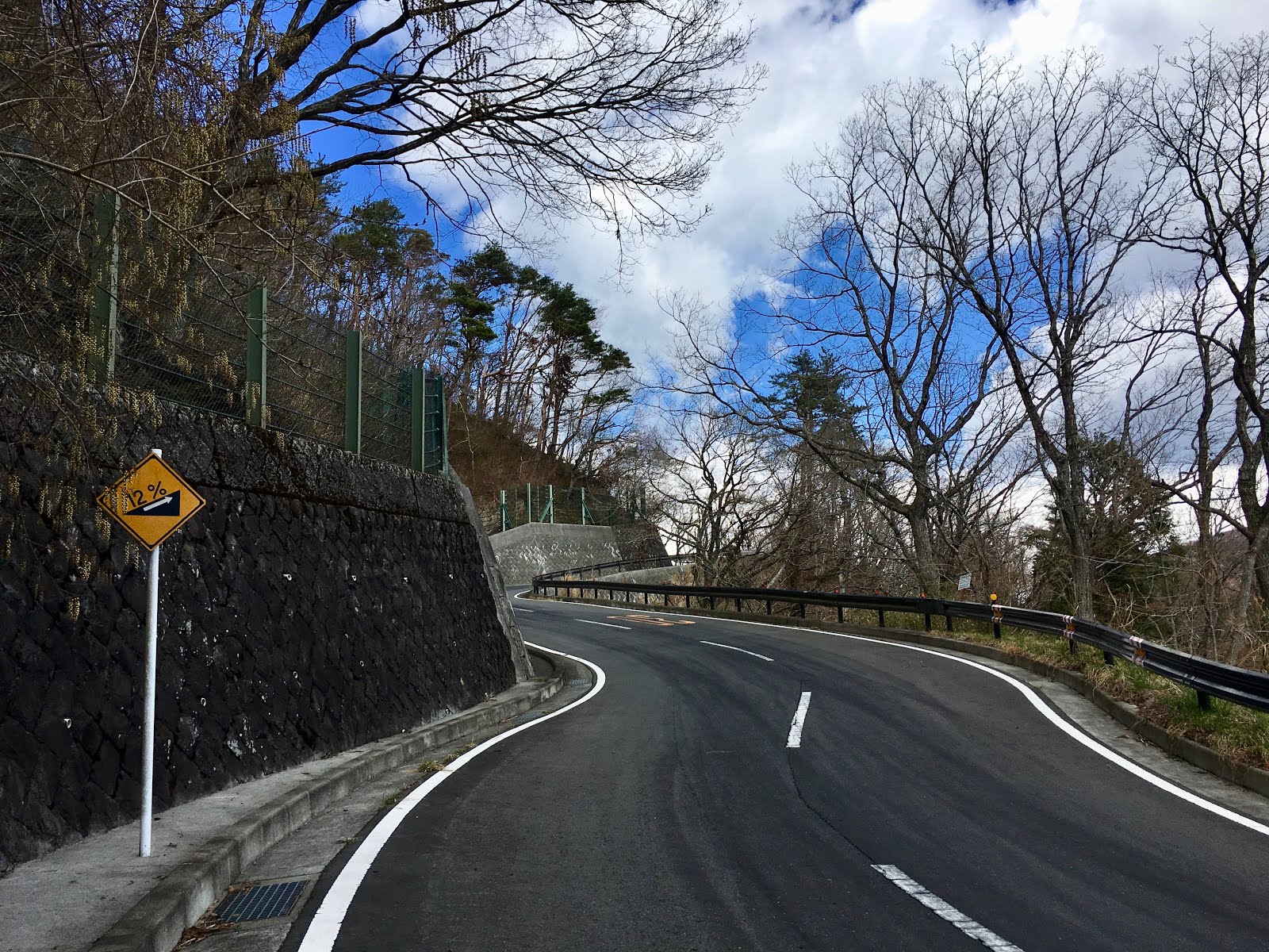
The climb is steep, 12% or more for stretches, and tops out at around 750 meters elevation. Over the top, the sky was a deep blue to the west, and I could see Mt. Fuji. I took a minor forest road on the descent through dappled sun toward Ashigara Station. More photo stops!

Looking down toward Ashigara Station and Mt Fuji.
I decided to go for Mikuni Pass. Mikuni is on the Olympic men's road race course for 2020. This pass is crazy steep -- like Mortirolo in Italy, or Kazahari Rindo. Not quite like the Angliru or Zoncolan in Spain, but definitely more than 2x Wada Pass.

I had only climbed it once before ... after doing a hill climb race up the Toyo Tires Turnpike out of Odawara. That was miserable, legs already quite tired from the race, and there are parts of the climb that are not only steep, but lack shade. Today was cool, but the climb still defeated me. Ashigara Station was around 325m elevation, and the top of the climb was 1150m or so. The real climb starts just west of the Fuji International Speedway and includes 700 meters vertical, immediately exceeding a 10% grade. Much of it is 12-18%. The famed "concrete donuts" are the steepest 18% part, but I had not remembered all of the other steep parts. I rested, and I walked, defeated by the grade. I remounted and finally made it to the top of the steep section, on the border between Shizuoka and Kanagawa. From there it is only a few km of more reasonable (5-10% grade) climb to the border with Yamanashi Prefecture.

No place to go but up.

The infamous concrete donuts. Lots of 16%, 12% and other warning signs too.
At the Shizuoka/Kanagawa border, end of the torture, now just a normal grade ahead.
"Mikuni" (三国) means "three countries", and is a typical name for a pass that borders three different jurisdictions. There are other Mikuni passes, just as "ryogoku" (両国) pass is for a pass the borders "both countries". There are plenty of those also. And of course, there are multiple Wada Passes, and Yamabushi Passes. And plenty of Mount Myojin's as well.  I think we need a re-naming initiative. Maybe this Mikuni Pass, or the nearby Yamabushi Pass, should be "Yamanaka-ko Gateway Pass" (山中湖ゲートウェイ峠)?


Anyway, the view over Mikuni of Mt. Fuji close up was spectacular. Every time I come to Yamanakako it seems a different Fuji is on view. From here I took a much more familiar route -- the short climb over Yamabushi Pass, down Doshi Michi, then a right turn to Miyagase ko and Atsugi where I hopped the train home ... with a short ride from Nogizaka on the Chiyoda Line back to Takanawa.


Doshimichi also looks like "Olympic Road Race Central".
They even have added lots of bike parking racks at the michi-no-eki.
The last light faded as I climbed to Miyagase-ko.

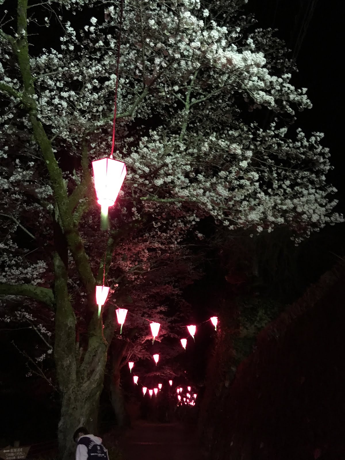
On the dark descent to Atsugi, I was drawn by lanterns up a side road and a hillside as far as I could see. This was Iiyama-san. The lanterns were to light a row of sakura that climbed along a stream and then up to the temple. It was not crowded, but there were families and individuals strolling. I walked my bike under the lovely canopy. Then rode back down the hill and into Atsugi. A perfect surprise end for a spectacular day on the bicycle.


Only 121km for the main ride, but 2300-2400 meters of climbing, not easy climbing.


03 October 2011

Super HC Up Toyo Tires Turnpike -- A Tradition Since 2010

On Sunday I joined the second annual "Super Hill Climb" event as one of six participants from TCC (Tokyo Cycling Club).  After a nice early warm-up ride to Shin-Yokohama Station, the Kodama shinkansen deposited me at Odawara after a trip of only 15 minutes.  Outside Odawara Station there were at least 10 Japanese riders taking road bicycles out of their rinko-bukuro.  It was only a few kilometers' ride to the start, and offered a great close-up view of Odawara Castle.

4 out of the 6 TCC riders finished in under one hour.

I was the slowest of the 6, finishing at 1:05:50, 296 out of 507 in the 40-49 group ("Road D" group).  But for me this was a very good time, within 9 minutes of Thomas and Travis, whereas on the similar climb last week of O-Toge, I finished within 20 minutes of Thomas and 18 of Travis.  And the 507 riders in the 40-49 group all looked like typical Japanese "climbers" -- very low body fat, pencil thin types, some tough as nails.

The route, up the "Toyo Tires Turnpike", a toll road usually normally closed to bicycles, involved a climb over 10 km from just above sea level (25m elev) to around 1000m elev., then 3.3 km of riding up and down hills along the top of a ridge, until one last uphill sprint to the finish.  There is plenty of 13% grade, and several kilometers where the average grade is higher than 10%.  I tried to keep a 10-11 kph speed even on the steepest stretches, and was pleasantly surprised that I could do so.  Including the up and down sections along the ridge, the aggregate ascent is close to 1100 meters, much more than the Ekiden climb up Route 1 in Hakone.

After a brief rest at the top, my real ride began.  Down to the lake -- Ashinoko -- and up and down small hills along its Southern shore, in heavy weekend tourist car traffic.  It took longer than I expected to get to Sengokuhara, the flat-ish area at the East end of the lake, where the tourists were parking and hiking among the tall grasses.
Hakone, Sengokuhara, looking toward Otome-toge

Then a short climb up Route 138 toward Otome Pass, through a tunnel, then down, down to Gotemba, and on the first plausible road I turned off of 138 and struck off to the N/NE through the valley toward the base of the next climb, Mikuni Pass, stopping at a convenience store for spaghetti and to check a map and make sure I could get to the climb without too many detours.

Mikuni was relentless, starting at below 500m elev and peaking at over 1150m elev, and much of the way 13-16% grade.  At least it was reasonably cool. I got off the bike once for photos and some water when the "circular" pavement pattern appeared.
The dreaded circular pavement pattern. The grade was already crazy below here.
Unlike most roads, it did not change noticeably when the circles appeared.

I dismounted a second time higher up ... and needed to walk 100 meters or so up the hill and around a bend to find a place where I could actually manage to re-mount the bike and clip into my pedals safely.
The clouds got darker and darker, but we had dry roads all the way back to town.
The Mikuni climb flattens out a bit the last 2 kilometers or so to less than a 10% grade.  At least now I've climbed it once, and can go back another time to try it fresh from bottom to top without a foot down.
I met Jerome, who had ridden out to Yamanakako, and we enjoyed a fast trip down Doshi Michi and back into town in the failing light.

Around 175km and around 2500-3000m of climbing.  At last I think I am fully recovered from PBP.