 |
| Bike & Hike |
 |
| Jerome (in road shoes w/ cleat covers) |
 |
| Nice view ... from 1200 meters elevation. |
Saitama Audax brevets are usually named "Attack [place name]". Jerome's first 600km ride was, I believe, the
2011 version of "Attack Nihonkai" -- we rode from Iruma-shi (Saitama) to the southern outskirts of Niigata-shi on the Sea of Japan, and back. Yesterday, we were scheduled to ride the Saitama "Attack Ashitaka" (
アタック愛鷹) 300km brevet. Mt. Ashitaka is on the southern shoulder of Mt. Fuji. The route for this event heads SW from Iruma through Oume, Takao, and Sagamihara cities, then climbs up to Yamanakako via Doshimichi, over Yamabushi and then Kagozaka Passes, descends to Gotemba, then goes around the large volcanic cone-shaped Mt. Ashitaka by climbing up to Fuji Safari Park and then descending the far side down to the Sagami Bay ... before returning all the way to the start in Iruma. Indeed, this was the same course that
Jerome and I rode last October. I was definitely out of shape then, and there was a
lot of climbing (and a couple hours of cold hard rain). It took me 19 hours out of the 20 hr time limit to finish. I was hoping we could shave an hour or more off that time.
This weekend, Jerome had done another long ride on Saturday (200km plus more to/from the start/goal), so he was hoping to string two one-day rides together as preparation for a multi-day event like Cascade 1400.
We got to the start under Toyomizubashi in Iruma around 630AM via Jerome's car ... and no one was there. Checking the organizers' website, we saw a notice from nearly two weeks ago that the event had been postponed ... just like last weekend's 200km brevet by a different organizer, and Jerome's 400km Chiba ride last month. Other audax events have gone ahead without postponement ... indeed, I had checked the event's webpage, even downloaded the most recent cue sheet, just the day before, but I had not checked the general Saitama Audax "news and events" page where I would have found the notice. After apologizing to Jerome, we discussed what we would do. There we were in Iruma, 50km NW of our typical starting point, before 7AM on a Sunday of a 3-day holiday weekend. We quickly dismissed the idea of riding the 300km Mt. Ashitaka course. It passed many areas that are within riding distance of our homes. If instead we headed further west or northwest, we could ride territory that is out of reach for a typical day ride from west central Tokyo.
I suggested we head west toward Chichibu, go over one of the passes that avoids the tunnel on Route 299 (Shomaru Pass or Karibazaka Pass), then try Mitsumine Shrine to the far WSW of Chichibu City. If we got through with that string of climbs quickly (midday) and the weather held ... we might even try Saitama Route 210 through the wilds of deep western Saitama to Shigasaka Pass, and return back. We had never done Mitsumine, nor Route 210, by bicycle. (I had been to the shrine once by motor vehicle, as 99% of the arrivals travel).
 |
| Leaving Rte 299 for the climb to Shomaru Pass |
 |
| RAMAX leaning |
 |
| Jerome arrives at Shomaru Pass |
Jerome was slow starting out, no doubt due to his long ride on Saturday. I had the rare experience of easily leading him up the Shomaru climb and waiting at the top. We quickly descended into Chichibu City and found a Gusto family restaurant for breakfast along our route. We ordered a "volume" breakfast set from a touchpad at the table. A robot brought our food. It thanked us after we took our trays from its shelves, then happily returned toward the kitchen area. This was a new experience for both of us. Wow, I thought, I had no idea Gusto was using robot servers. I felt out of date, behind the times. The only human interactions were when we entered the restaurant (someone told us to sit anywhere we liked), and when I paid. I asked the employee how long they had been using the robot. She hesitated and seemed to be considering carefully the right response. "Nine days", she finally said. Okay, at least I did not feel so behind the times anymore.
 |
| Serving robot leaves after thanking us. |
We headed WSW taking a parallel road to Route 140 through much of SW Chichibu City. It had almost no traffic. Eventually the road ended and we rejoined Rte 140. A bit further on we pulled into the Arakawa michi-no-eki for a restroom break. As I returned to the bicycles, Jerome was talking with a woman cyclist. she had an Audax reflective vest, and a reflective triangle "slow vehicle" symbol as well. She told Jerome she had just come from Mitsumine Shrine. She was doing a Nihombashi Audax 300km ride that had NOT been cancelled. (Instead, they stretched out the start times to avoid any crowd or gathering at the start/goal.) She had started alone or nearly so in the middle of the night, ridden from central Tokyo, climbed Mitsumine Shrine (elev ~1000m) in what must have been quite cold temperatures and was on her way back. Respect.
We saw a few other Nihombashi audax riders headed back as we continued toward Mitsumine. But we had a different plan. Mitsumine can have heavy traffic on a narrow road. So some riders take a different route on the other (NE) side of the mountain all the way up to around 1220m elevation, through a short tunnel, and descend to the shrine at just over 1000m. Indeed, this route has even been used for a hill climb race at times in the past. Our plan was to take this rindo, then after a quick lunch at the shrine, to descend the main road.
 |
| Onto the climb - beautiful and empty road. |
We found the turnoff and started the climb. Jerome lagged -- unusually -- his fatigue from the day before still showing. It was a lovely road -- wide, empty, and not TOO steep -- all the way up a valley to a "fishing spot" (釣り場) that had a parking lot full of cars. From there, the road turned up steeply and was blocked by some "no way through" signs and pylons. On the left side, however, there was a note that visitors to Taiyou-ji temple should move the barriers and proceed.
 |
| Lots of these signs up here. |
 |
| On the left side is the note that visitors to Taiyou-ji may proceed. |
 |
| A nice spot to rest and wait a bit for a tired Jerome |
I rode to the next switchback, where there was a babbling brook and I could wait for Jerome in the sunlight. The next segment was to the turn off for Taiyou-ji. Here was another gate across the road we would take. There was a helpful sign that the road led to a trailhead for the climb up Mt. Kirimogamine.
We continued, but soon found sections where the road was covered with snow, only tire tracks exposed. We could ride in the tracks, but needed to be careful and watch for icy patches. In some places, the snow was a bit deeper and crustier, and so riding into the edge of the track would be dangerous. We proceeded slowly, walking at times.
 |
| No more tire tracks ... only an animal. |
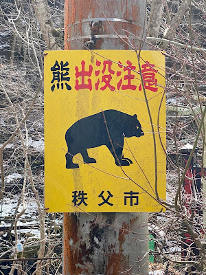
Finally we passed the Kiromogamine trailhead, marked by a small gazebo/picnic table. The tire tracks ended here and the road headed around a bend so it was on a north facing slope that did not get sunlight. On the next snowy section there were only ... animal tracks. Deer? I saw three further up the hill. Bear? We saw MANY bear warning signs but no bears... perhaps the local bears were still hibernating. Or else they had awoken and were very hungry?
From here, the last 2+ kms to the tunnel through the mountain, we would walk the entire way, sometimes pushing and sometimes carrying our bikes where the snow got deeper.
 |
| More animal tracks |
I was glad to have MTB shoes. Jerome, meanwhile, had road shoes with rubber covers on his Look Keo cleats. Not ideal for this long a walk! But we made it. It was a long traverse, it was cold at 1200m elevation in the snow, it was not so easy to walk carrying a bike. But it was never so far, nor so cold, nor so hard that we considered turning back. The vista was spectacular, its own reward. I am afraid that the average speed for our ride ... dropped pretty precipitiously on this climb. On Strava I could see that I was the third fastest to do the climb this year ... out of three. The other two were recorded in early January, before the snowfall, and must have just ridden up at a good pace.
Once through the short tunnel, we could quickly descend the rindo to Mitsumine. There were plenty of snowy stretches still, but on this side the snow on the road was wet and at most a few centimeters deep. We could ride through it downhill being careful not to go too fast, nor to brake or turn suddenly. We knew we were approaching the shrine when we came to another closed gate ... and a huge parking lot full of cars.
 |
| Outer gate to the Mitsumine Shrine complex |
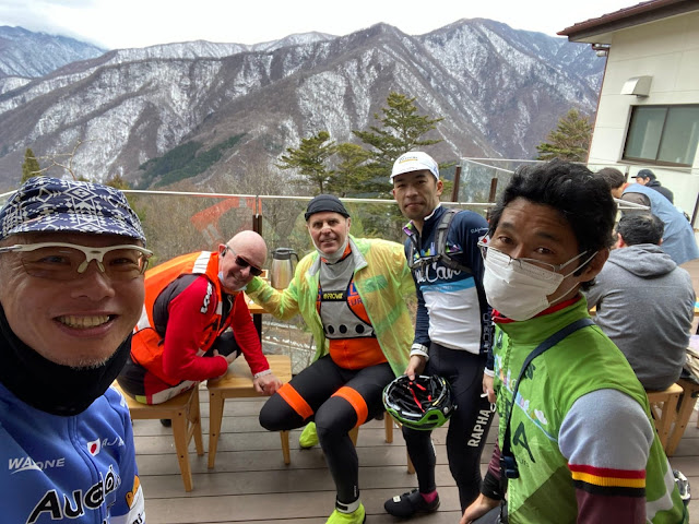
We went up the path toward the shrine entrance and found a cafeteria full of visitors. There were three bicycles together out front. No audax rear-triangles, but they looked as if they might be part of our extended Audax family. Sure enough, we entered to find Messrs. Minoda (Aoba organizer), Tachibana (Gunma organizer) and Shimura. Shimura-san's bike was a beautiful titanium SEVEN, with his name painted on the top tube. Minoda-san we have known a long time from Aoba rides and as a local -- I would come across him on his daily commute down (then up) the Tamagawa Kawasaki occasionally when I lived near Futako Tamagawa. Tachibana-san I've also met before on rides. I follow him on Strava and am always amazed to see him racking up 200km+ rides on a typical weekend. He has already gone over 9,000 kms this year ... a significant share of that on Zwift.
 |
| Messrs Shimura, Minoda, and Tachibana |
 |
| On the veranda |
 |
| I think Jerome and I burned a few more calories than they did on the climb! |
Jerome and I could only get a seat quickly on the veranda outside ... but we could warm ourselves by the wood stove inside then sip hot tea as we waited for our food, and were relieved that the glass wind barrier kept it quite warm even on the veranda outside of the restaurant. The other three audax riders said farewell and headed down the hill and we relaxed and finished our meal.
We got on our bikes and started down the hill ... first passing what seemed like at least a kilometer long line of cars waiting patiently to enter the parking lot. I was glad we had come up the rindo, and very glad not to be arriving there by motor vehicle. Most of the descent was fast ... switchbacks that were long enough to gather up good speed yet still brake in plenty of time for the curve. On the RAMAX, I could descent with confidence, the disk brakes working like a charm. After we were more than halfway down, the road narrowed. At points we waited behind a car that had stopped to let opposing traffic pass. Jerome said "they need a more powerful politician." Indeed, this route gets enough traffic so it would seem to merit some sky bridges like Yanagisawa Pass on Route 411!
 |
| I'm thankful I did not drive here. |
In any event, at the bottom of the hill, there was a red light and a line of cars, just before the road narrows to a single lane to cross over the spillway of a dam. Jerome went ahead and I followed. We were almost across when the line of opposing traffic came at us ... but there was plenty of room for two bicycles to slide by without inconveniencing them. We saved at least 5 minutes right there. Further down the hill we can to another long 3-way traffic signal ... and were able to move by the cars, to the front of the line ... and there we met the three riders who had left at least ten minutes ahead of us.
 |
| I'm on the drops in front. |
The five of us rode together to Chichibu. Jerome and I could hang with them well on the gradual downhill ... but we lost contact on the flat stretch going into town, riding along a line of cars. Those guys are all very strong riders! We caught them again ... as they waited at a light, and said our farewells. They were heading back to town via 299 and Yamabushi Pass. We were heading in a large arch to Yorii and then down along the east side of the mountains back to Hanno/Iruma.
The rest of the ride was ... around 25 kms arching to the north/east, parallel to the Arakawa as it flows from Chichibu City through Nagatoro and to Yorii, then another 40+kms to the southeast via Ogawamachi, Ogose, Moroyama, Hidaka, Hanno, and finally to Iruma. By far the longest stretch was heading southeast on Saitama Route 30, a very familiar road. Finally, we turned off onto Saitama Route 262 for the last stretch into Iruma ... the short ups and downs on this stretch reminded me of past Saitama brevets starting at Toyomizubashi, even that 2011 "Attack Nihonkai".
 |
| Across the road from our convenience store food stop in Chichibu City |
 |
| Near dusk, passing Yorii |
We made excellent time on the last 65kms ... with Jerome pulling or at least leading much of the last 40 from Yorii back to Iruma, because he had his iphone attached to his handlebars and had the route visible, whereas I did not have it in my Wahoo. But other than a brief stretch where I felt as if I were "riding-while-digesting" after food stops in Chichibu City in both directions, I felt pretty strong the entire day. The RAMAX is now officially dialed-in and is very comfortable. With the Panaracer Gravel King 700x28 tires, it both climbed and descended very nicely. With a 120mm stem, my body position is just right. Nothing ached after 185kms and 2300m of climbing. The bike continued to feel comfortable for the long cruising stretch back to Iruma. The only pain I suffered alld ay was some "hot foot" later in the ride, but a minor tweak to the location of the right shoe's cleat seemed to resolve that entirely.
The RAMAX model name means "Randonneuring Adventure MAXimum" ... and today we did our best to live up to that.


